What is recorded here
Thirty-one stones stand in a trapezoid of grass, the oldest carved in 1766, while a new church rose nearby in 1849 and the old one vanished beneath rubble. The graveyard still receives the dead, but the watch house and sacred enclosure have surrendered their shapes to time. It is a place where memory depends on stone because earth forgot the rest.
Trapezoidal overgrown graveyard (c. 50m E-W; c. 60m N-S), still in occasional use; Henchion (1989) records 31 inscribed headstones dating from 1766. Rectangular structure (6m x 2m) to S may be remains of watch house, marked on 1842 OS 6-inch map. Contained parish church (CO098-037004-) of Cullen which was in repair 1615 & 1639 (Brady 1863, vol. 1, 327-8); Lewis (1837, vol. 1, 442) records 'some ruins of the old church'. By 1842 OS 6-inch map shows newly erected C of I church (CO098-037003-) immediately NE of old church, this was concecrated 'under the name of Christ Church' (Brady ibid., 71) in 1849; now reduced to low mound of rubble; no visible surface trace of earlier church. Surrounding this is extensive early ecclesiastical enclosure (5160) (Hurley 1980, 56).
The above description is derived from the published 'Archaeological Inventory of County Cork. Volume 2: East and South Cork' (Dublin: Stationery Office, 1994). In certain instances the entries have been revised and updated in the light of recent research.
Date of upload/revision: 14 January 2009
The monument record does not grant public access. Check the route and ask the landowner before entering private land.
- What survives
- Recorded monument
Places near here
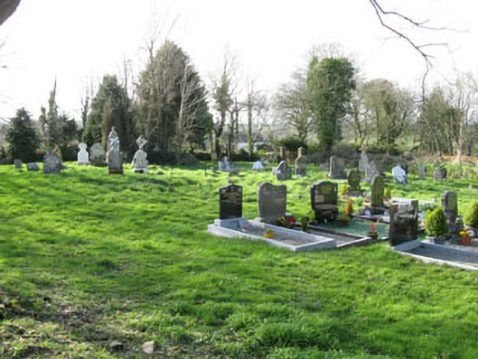 Cullen Graveyardchurch/chapel · 12 yd
 Church in CullenChurch · 17 yd
 IndicatedEcclesiastical enclosure · 67 yd
 St Laitiarain's WellSpring · 156 yd
 Cullen Castle (Site of)Castle, unclassified · 565 yd
 Enclosure in CullenEnclosure · 619 yd
 Dinny Barry MemorialMemorial · 1403 yd
 Curra WoodForest · 1.1 mi
 Pallastown WoodWood · 2.8 mi
 Meadstown Castle (Site of)Castle, unclassified · 2.9 mi
 Graveyard in ArdbrackGraveyard · 4.6 mi
 Dermot Ryan's Heritage Town WalksHeritage attraction · 4.8 mi