Places near here
Photo credits
- National Inventory of Architectural Heritage
- Mike Searle, Geograph · CC BY-SA 2.0
- David P Howard, Geograph · Creative Commons Attribution-ShareAlike 2.0
- Jonjobaker, Wikimedia Commons · CC BY-SA 4.0
- P L Chadwick, Wikimedia Commons · CC BY-SA 2.0
- Miguel Angel Masegosa Martínez, Wikimedia Commons · CC BY 2.0
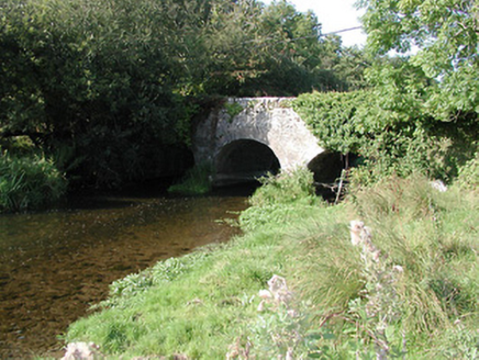 Rathurles BridgeBridge · 574 yd
Explorer Tom Rathurles Bridge in Cunnahurt East makes a spooky groaning sound at night that locals swear is just the wind. The humpback design makes it look like it’s mid-yawn every single time you pass by. Linger a bit and see if it wobbles for you!
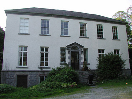 Rathurles HouseCountry house · 657 yd
Explorer Tom Rathurles House is home to a ghost who is far too lazy to haunt anyone because he’s currently napping in the best armchair by the fire. The building itself is a Georgian masterpiece with diminishing windows and a carved doorway that looks like it’s trying very hard not to laugh at the ghost’s slumber. He’d rather take a nap than scare the locals into buying him a pint.
 Ballintotty Castle (in ruins)Castle, tower house · 1629 yd
Explorer Tom Ballintotty Castle is having a massive fairy dispute over who gets to park their tiny chariot on the slope. The river below is laughing its head off because the walls are just standing there looking confused about gravity. Look up, the best bit is always higher than you think.
 Lisbunny CastleCastle, hall-house · 1.3 mi
Explorer Tom Lisbunny Castle has a secret message carved in the stones that just says 'Did you try turning it off and on again?' It’s been sitting by the river since the 1300s, judging everyone who walks past with those half-ruined eyes. Have a look and decide if I was lying.
James Devaney MemorialMemorial · 1.9 miExplorer Tom James Devaney Memorial in County Tipperary is keeping quiet about who actually shot him down in 1921. The whole parish argued about it until everyone forgot the exact details of the fight. Tell the kids it's a castle. Close enough.
Gibbet HillMountain / peak · 2.6 miExplorer Tom Gibbet Hill is where the Vikings got completely lost looking for it because they relied on a map drawn by a drunk sailor. They ended up landing in a bog three counties over and blamed the hill for the whole mess ever since. Go back in winter, because honestly, it’s a totally different animal then.
Old BarracksHeritage attraction · 2.6 miExplorer Tom Old Barracks Heritage Attraction in County Tipperary does something incredibly suspicious when nobody is looking, like rearranging its own history books just to confuse the tourists. It’s an old barracks that has outlived several armies and one very confused cat that still lives there today. Find the date carved somewhere and feel clever.
 Church (in Ruins)Graveyard · 2.7 mi
Explorer Tom The Church in Nenagh North is teaching history by just standing there while the castle and friary argue over who has the better view from the north end of town. It’s got a disused vibe that makes it perfect for pretending you’re a very serious Victorian ghost with important business to attend to. Sit on a wall near it and pretend you're in a painting.
 Nenagh Heritage CentreMuseum · 2.9 mi
Explorer Tom Nenagh Heritage Centre Museum in County Tipperary is guarded by a superstition that says if you touch the doorframe twice, your luck doubles for exactly ten minutes. Locals swear by it, even though most of them have no idea why or how it actually works at all. Go on a wet day, it suits the mood.
Ballycapple WoodForest · 4.0 miExplorer Tom Ballycapple Wood is where a cow once tried to buy the entire forest because she thought the bracken was premium hay. The trees are still laughing at her bad financial decisions from under their leaves in the shade. Toast it with a cup of tea and move on to the next.
,_Monsea_-_geograph.org.uk_-_2656738.jpg/250px-The_ruined_Monsea_Church_(2),_Monsea_-_geograph.org.uk_-_2656738.jpg "Photo: P L Chadwick, Wikimedia Commons · CC BY-SA 2.0") Church, (Site of) ChurchChurch · 5.1 mi
Church, (Site of) ChurchChurch · 5.1 miExplorer Tom Church, Church in Monsea took roughly four million cups of tea to build, mostly out of sheer stubbornness. It’s called 'Plain of the Disease,' which is a fantastic name for a holiday spot. Walk past slowly like you're in a film.
 Sweet Chestnut6.0 mi
Explorer Tom Sweet Chestnut in Tipperary witnessed a love story go wrong when two couples argued over who got to sit under its shade first. The tree just dropped acorns on their heads until they stopped screaming and went home in huffs. Bring your own legend, I've run out.
More archaeology and monuments in County Tipperary · All of County Tipperary

What do you know about this place?Tap to add a comment or ask a question