
What is recorded here
From the Northern Ireland Sites and Monuments Record record FER230:049
Places near here
Photo credits
- Jonathan Billinger, Wikimedia Commons · CC BY-SA 2.0
- Dean Molyneaux, Wikimedia Commons · CC BY-SA 2.0
- Maker not stated on source page, uk.pinterest.com
- Maker not stated on source page, www.flickr.com
- Maker not stated on source page, en.wikipedia.org
- Maker not stated on source page, www.youtube.com
- Maker not stated on source page, tr.pinterest.com
- Maker not stated on source page, bamni.co.uk
- Maker not stated on source page, www.geograph.ie
- Maker not stated on source page, www.pinterest.com
- Maker not stated on source page, ru.pinterest.com
 Carry BridgeBridge · 278 yd
Explorer Tom Carry Bridge in County Fermanagh has a family tree that’s mostly made up of lies and old grudges. I heard its…
 St. Michael's ChurchChurch · 779 yd
Explorer Tom St. Michael's Church in County Fermanagh is allegedly where a smuggler hid a whole barrel of whiskey behind the altar…
 Barrow cemetery & burnt mounds (Fulachta Fiadh) in DerryharneyBarrow cemetery & burnt mounds (Fulachta Fiadh) · 931 yd
Explorer Tom Barrow cemetery & burnt mounds in Derryharney hears the ghosts complaining about the dampness through its thick stone…
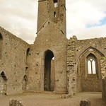 Dominican & Franciscan Abbey in GolaDominican & Franciscan Abbey · 968 yd
Explorer Tom Dominican & Franciscan Abbey in Gola is two orders of monks who couldn't agree on anything except staying put. It…
 Linear earthwork in DrummeeLinear Earthwork · 997 yd
Explorer Tom Linear earthwork in Drummee is just a long line of dirt arguing with another line of dirt over who owns the view. Two…
 Black bog Wood, Belle IsleWalking route · 1444 yd
Explorer Tom Black bog Wood, Belle Isle is absolutely sick of people asking if the trees are sad because it’s called Black Bog Wood.…
 Castle in CorrardCastle · 1.7 mi
Explorer Tom Castle in Corrard is uncertain, which means it could be anything from a palace to a pile of dirt. The shortcut isn't a…
 Platform rath in Killygowan IslandPlatform Rath · 2.0 mi
Explorer Tom Platform rath on Killygowan Island is proud of being an island fortress, even if it’s mostly just a very committed…
 Castle (unlocated) in DerrychullaCastle (unlocated) · 4.6 mi
Explorer Tom Castle in Derrychulla is unlocated, which means you’re looking for a castle that might not be where you think. It’s…
 Friars IslandIsland · 4.6 mi
Explorer Tom Friars Island in Fermanagh is named after monks who probably left a cow behind by accident, and that cow somehow tried…
 Mapped graveyardGraveyard · 4.8 mi
Explorer Tom Its favourite song is definitely the sound of rain hitting the slate, because it’s the only music that doesn’t require…
 Mapped cemeteryCemetery · 4.9 mi
Explorer Tom "Mapped cemetery has a fierce rivalry with a much more famous castle nearby, constantly trying to one-up it by being…
More archaeology and monuments in County Fermanagh · All of County Fermanagh

What do you know about this place?Tap to add a comment or ask a question