
What is recorded here
From OpenStreetMap (© OpenStreetMap contributors) n8951771771
Places near here
Picture notes
- Computer-made picture. It does not show this monument.
- sarah gallagher, Geograph · CC BY-SA 2.0
- National Inventory of Architectural Heritage
- Kenneth Allen, Geograph · CC BY-SA 2.0
- Computer-made picture. It does not show this playground.
- Computer-made picture. It does not show this walking route.
- Richard Webb, Geograph · CC BY-SA 2.0
- Computer-made picture. It does not show this mountain top.
 Gortnavern Earthen Mound / Former FortMound · 339 ydComputer-made picture
Explorer Tom Gortnavern Earthen Mound / Former Fort looks like a simple dome, but old maps called it a proper fort. The ridge is scarred with banks and gaps that might have been entrances. It’s tough to tell what was what here, but the commanding view over the pass is undeniably impressive.
 Rough IslandIslet · 916 yd
Explorer Tom Another Rough Island in County Donegal, because apparently they needed a sequel to their first act. It sits there looking bored near Mulroy Bay. Ten minutes here and you'll have a yarn for the pub.
 Fairy fort / ringfort in Raithnigh (tc An Cheathrú Chaol)Fairy fort / ringfort · 1034 ydComputer-made picture
Explorer Tom Fairy fort / ringfort in Raithnigh has been completely removed from the flat pasture near Mulroy Bay. It’s gone so thoroughly that it feels like the land just swallowed it whole. I’d bet the cows there are walking over the exact spot where a fortress used to stand.
 The CurlewHouse · 1290 yd
Explorer Tom The Curlew overlooks Mulroy Bay from a rise near Carrowkeel. Built around 1910, it has stepped red and yellow brick chimneys and wavy timber trim on the gables. Those chimneys look rather pleased to have found such a good view.
 McGinley'sPub · 1614 yd
Explorer Tom McGinley's on Main Street has a guy who swears he saw a leprechaun pay his tab. He never left, probably still polishing glasses that aren't there in the back room. Wave at the cows, they're the real locals.
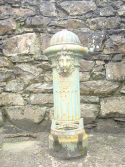 water pump1675 yd
Explorer Tom Water pump in Carrowkeel has a lion's head spout and a Scottish maker's mark from Kilmarnock. The heritage survey found it out of use. I picture the little iron lion proudly guarding a vanished water job, as though retirement were someone else's idea.
 The Village InnPub · 1696 yd
Explorer Tom The Village Inn sounds like it contains an actual village, but it’s just a pub on Main Street. Ask the bartender if he knows the local king; he probably doesn’t. Stick around for the light changing, it's a show.
 Children's playground1737 ydComputer-made picture
Explorer Tom Children's playground in County Donegal has a slide that definitely goes to the afterlife if you lean right. Just don’t ask me how I know about the exit route. Look for the ghost, then pretend you didn't see it at all.
 Woodquarter - Forest trailOfficial walking route · 1.1 miComputer-made picture
Explorer Tom Woodquarter Forest trail is a tiny loop that claims to be moderate in just half an hour. I’m not buying it until I see the bruises. Visit, then text me what you think. I’ll pretend to read it while eating chips.
 WoodquarterForest recreation place · 1.1 mi
Explorer Tom Woodquarter sits by Mulroy Bay where Lord Leitrim got murdered in 1878, adding some spice to the forest planting later on. The trees are just along for the ride now, pretending they didn’t witness the whole bloody mess. Tell me if the gossip I made up is actually true.
 CrockmoreMountain / peak · 1.2 miComputer-made picture
Explorer Tom This other Crockmore looks exactly like the last one but with slightly more attitude. It’s probably trying to outdo its namesake for no reason. Stand back, squint, and it looks like a castle in your mind's eye.
 CraigcannonMountain / peak · 2.3 miComputer-made picture
Explorer Tom Craigcannon sounds like something that goes boom, but it’s just sitting there quietly. Probably plotting world domination from the top. Bring wellies and low expectations, leave delighted, and don't look for the cannon, it’s imaginary anyway.
More mountains and hills in County Donegal · All of County Donegal

What do you know about this place?Tap to add a comment or ask a question