What is recorded here
Randolph Colliery is a colliery in Fife, Scotland.
From the Historic Environment Scotland record 131528
The historic-place record does not grant public access. Check current conditions and ownership before entering land or a building.
Places near here
Photo credits
- James Allan, Wikimedia Commons · CC BY-SA 2.0
- JThomas, Wikimedia Commons · CC BY-SA 2.0
- Becky Williamson, Wikimedia Commons · CC BY-SA 2.0
- Mat Fascione, Wikimedia Commons · CC BY-SA 2.0
- Richard Sutcliffe, Wikimedia Commons · CC BY-SA 2.0
- Jim Bain, Wikimedia Commons · CC BY-SA 2.0
- Richard Webb, Wikimedia Commons · CC BY-SA 2.0
- Douglas Nelson, Wikimedia Commons · CC BY-SA 2.0
 CowdenlawsFarmhouse, Farmstead · 429 yd
 PhantassieHouse (19th Century) · 887 yd
 BowhouseMilestone (19th Century) · 1389 yd
 Moss WoodWood · 1564 yd
 ThorntonMile Plate (19th Century) · 1.2 mi
 Frances Colliery MemorialMemorial · 1.3 mi
 War MemorialMemorial · 1.3 mi
 Safir: West Wemyss Harbour, Firth of ForthSchooner (19th Century) · 1.4 mi
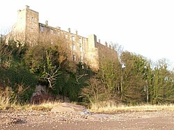 Wemyss CastleHospital (first World War), Sundial(s), Tower House (16th Century) · 1.7 mi
 West WemyssCave(s) · 1.7 mi
 Middle DenWood · 2.1 mi
 Ravenscraig CastleArtillery Fortification (15th Century), Castle (medieval) · 2.2 mi
More archaeology and monuments in Fife · All of Fife
What do you know about this place?