
What is recorded here
Frances Colliery Memorial is a memorial in Fife, Scotland.
From OpenStreetMap (© OpenStreetMap contributors) n4991345552
Places near here
Photo credits
- Richard Webb, Wikimedia Commons · CC BY-SA 2.0
- JThomas, Wikimedia Commons · CC BY-SA 2.0
- Colin Smith, Wikimedia Commons · CC BY-SA 2.0
- Richard Sutcliffe, Wikimedia Commons · CC BY-SA 2.0
- Bill Kasman, Wikimedia Commons · CC BY-SA 2.0
- Douglas Nelson, Wikimedia Commons · CC BY-SA 2.0
- Mat Fascione, Wikimedia Commons · CC BY-SA 2.0
- NASA, Wikimedia Commons · Public domain
- Jim Bain, Wikimedia Commons · CC BY-SA 2.0
 DysartBuilding · 195 yd
 Normand Road, DysartBench Mark (19th Century), Milestone (19th Century) · 475 yd
 Dysart, Normand Road, Dysart Primary SchoolSchool · 489 yd
 Dysart, High Street, the Cross Jubilee LampLamp · 725 yd
 Lady Blanche CollieryMemorial · 835 yd
 John McDouall Stuart Memorial PlaqueMemorial · 837 yd
 Safir: West Wemyss Harbour, Firth of ForthSchooner (19th Century) · 1.1 mi
 Ravenscraig CastleArtillery Fortification (15th Century), Castle (medieval) · 1.3 mi
 Pathhead SandsBeach / strand · 1.4 mi
 Firth of ForthBay · 1.5 mi
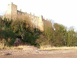 Wemyss CastleHospital (first World War), Sundial(s), Tower House (16th Century) · 1.6 mi
 Middle DenWood · 1.9 mi
More memorials and graveyards in Fife · All of Fife

What do you know about this place?Tap to add a comment or ask a question