
Places near here
Photo credits
- David Baird, Wikimedia Commons · CC BY-SA 2.0
- Anne Burgess, Wikimedia Commons · CC BY-SA 2.0
- National Inventory of Architectural Heritage
- C Michael Hogan, Wikimedia Commons · CC BY-SA 2.0
- Rossographer, Geograph · CC BY-SA 2.0
- Rossographer, Geograph · Creative Commons Attribution-ShareAlike 2.0
- Kenneth Allen, Geograph · CC BY-SA 2.0
- Chris Gunns, Geograph · CC BY-SA 2.0
- N Chadwick, Wikimedia Commons · CC BY-SA 2.0
- N Chadwick, Geograph · CC BY-SA 2.0
 Cliffs near Pollaguill BayPublicly named cliff or headland · 794 yd
Explorer Tom Cliffs near Pollaguill Bay have a secret weapon: giant boulders thrown up by winter storms that look like alien eggs. The photo doesn’t do justice to how chaotic those rocks are. It’s a wild mix of sand and stone, so tread carefully.
 Cliffs near ClagganPublicly named cliff or headland · 1503 yd
Explorer Tom Cliffs near Claggan are basically the sea’s way of saying ‘stay back’ to anyone who gets too close. They’re rugged and unapologetic about their height. If you’re exploring there, watch out for loose bits falling into the waves below, it’s messy.
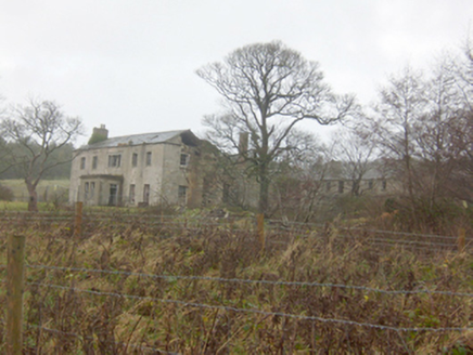 Horn Head HouseCountry house · 1718 yd
Explorer Tom Horn Head House is the largest country house in this part of Donegal, sadly now derelict but still substantial. It’s got that mid-eighteenth-century classical proportion with windows diminishing towards the eaves. Give it a mournful wave as you pass by.
 Horn Head Portal TombPortal tomb · 1.2 mi
Explorer Tom Horn Head Portal Tomb sits right on the edge of the valley, looking out toward Tory Island. The roof is missing, so you’re essentially staring at the sky through a 33-metre-long stone corridor. It’s been leaning and settling since the Bronze Age, but that view? Absolutely worth the squint.
 Tramore StrandBeach / strand · 1.2 mi
Explorer Tom There are two Tramore Strands in Donegal, and this one near Dunfanaghy makes you earn the sand. The local guide sends you along a tree-lined path for about 30 minutes before the two-mile beach shows itself. I would give it a grand entrance; the dangerous currents mean my swimming trunks can stay in the bag.
 Hornhead BridgeBridge · 1.2 mi
Explorer Tom Hornhead Bridge is a picturesque stone masterpiece right there in Figart, proving that masons back then knew their stuff. It connects the Horn Head Peninsula to the mainland with real architectural merit. Go cross it and tell me if your heart rate goes up a bit!
 Patsy Dan'sPub · 1.7 mi
Explorer Tom Patsy Dan's pub in Dunfanaghy has an escape plan for its first owner that involves a window and a lot of luck. I bet Patsy Dan is a ghost who still owes the tab to the previous owner. Go on, count the windows and get it wrong like I did.
 Muck n' MuffinsCafé · 1.7 mi
Explorer Tom Muck n' Muffins in Donegal is a café where the rabbits think the muffins are actually just fancy mud pies. They serve coffee that tastes like it’s been brewed by a wizard with a grudge. Spot the oldest stone and give it a name.
 CrocksheeMountain / peak · 1.8 mi
Explorer Tom Crockshee sits in County Donegal, and the map record is as bare-bones as a mountain can be. The picture caption notes it’s visible from Coastguard Hill, three kilometres from Dunfanaghy, which makes me wonder if it’s just standing there, quietly judging my hiking boots.
 Local Wildlife presentationVisitor information · 2.0 mi
Explorer Tom Local Wildlife presentation at New Lake is beautifully painted by hand, though the paint is peeling like my motivation. The local sheep think it’s a bit pretentious. Practise your Irish on it; it won't correct your grammar.
 Cairn, Coastguard HillPublicly named cairn · 2.0 mi
Explorer Tom Cairn, Coastguard Hill is a place where the name itself tells you it’s on a hill with a view of the sea. I imagine standing there and seeing how far out the water goes, which would have been perfect for spotting ships or just enjoying the wind. It’s one of those spots that feels like it was chosen for its vantage point.
 Coastguard HillMountain / peak · 2.0 mi
Explorer Tom Coastguard Hill is where you go to look for ships that aren't there. I saw a whale once, probably a cloud shaped like a whale. Ten minutes here and you'll have a yarn for the pub that nobody will believe.
More mountains and hills in County Donegal · All of County Donegal

What do you know about this place?Tap to add a comment or ask a question