What is recorded here
From OpenStreetMap (© OpenStreetMap contributors) n5330120575
Places near here
Picture notes
- Computer-made picture. It does not show this monument.
- National Inventory of Architectural Heritage
- Computer-made picture. It does not show this walking route.
- Alvesgaspar, Wikimedia Commons · CC BY-SA 3.0
- Roger Diel, Geograph · CC BY-SA 2.0
- Computer-made picture. It does not show this garden.
- Algirdas at Lithuanian Wikipedia, Wikimedia Commons · Public domain
- Colin Park, Geograph · CC BY-SA 2.0
- Computer-made picture. It does not show this playground.
 Enclosure in BallydonaghanEnclosure · 463 ydTom: I’m here to help · Computer-made picture. It does not show this monument.
Explorer Tom Enclosure in Ballydonaghan is an archaeological puzzle piece, but please be nice and ask the owner before stepping onto private ground.
 Enclosure in CaherhurlyEnclosure · 737 ydTom: I’m here to help · Computer-made picture. It does not show this monument.
Explorer Tom Another Enclosure in Caherhurly keeps quiet, with no digital details yet to tell us exactly what lies beneath the grass.
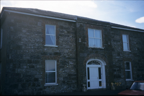 Fort EdwardHouse · 1607 yd
Explorer Tom Fort Edward’s breakfront facade hints at its grand history, standing as a quiet parochial house in Coolready today.
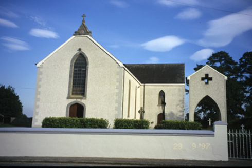 Catholic Church of Our Lady of the AssumptionChurch/chapel · 1687 yd
Explorer Tom Coolready’s Church of Our Lady of the Assumption was built in 1844 and features a Tudor arch door and leaded coloured glass lancet windows.
 East Clare WayWalking route · 1.5 miTom: I’m here to help · Computer-made picture. It does not show this walking route.
Explorer Tom East Clare Way in County Clare stretches far into the distance. It's a long haul, but worth it! Pack extra snacks because you'll burn them off fast.
 Common Lime2.6 mi
Explorer Tom A common lime tree could be offering dappled shade nearby, though we haven’t exactly pinned down its location yet.
 Ballynahinch Castle (in Ruins)Castle, unclassified · 3.4 mi
Explorer Tom Imagine Donald MacNamara’s 1475 castle, once reachable only by boat when water levels were higher.
 Community GardenGarden · 3.4 miTom: I’m here to help · Computer-made picture. It does not show this garden.
Explorer Tom Community Garden, a garden in County Clare, is a space where neighbors come together to grow, share, and thrive.
 Pedunculate Oak3.6 mi
Explorer Tom Another majestic pedunculate oak could be spreading its wide branches, offering a perfect spot to rest and reflect.
 MoylussaMountain / peak · 3.7 mi
Explorer Tom Moylussa, a peak that’s as rugged as the moorland that surrounds it in County Clare.
 Violet Hill Loop WalkWalking route · 4.3 miTom: I’m here to help · Computer-made picture. It does not show this walking route.
Explorer Tom Violet Hill Loop Walk sounds like a rave gone wrong in the hills. There's no record of access, which means bring your own rope and a sense of adventure.
 Children's playground4.5 miTom: I’m here to help · Computer-made picture. It does not show this playground.
Explorer Tom This children's playground is a spot where imagination runs wild and fun is always around the corner.
More mountains and hills in County Clare · All of County Clare

What do you know about this place?Tap to add a comment or ask a question