
Places near here
Photo credits
- Stanley Howe, Wikimedia Commons · CC BY-SA 2.0
- Colin Smith, Wikimedia Commons · CC BY-SA 2.0
- Alan Findlay, Wikimedia Commons · CC BY-SA 2.0
 Schoolhill, Old School HouseHouse, School · 657 yd
 GreendamsFarmhouse, Farmstead · 797 yd
 BlackdamsBuilding(s), Farmhouse, Farmstead · 921 yd
 North CandyglirachEnclosure · 923 yd
 WestertonFarmstead · 983 yd
 CullerlieLeaf Arrowhead(s) (flint) · 1027 yd
 West CullerleyFarmhouse, Farmstead · 1130 yd
 Quartains MossForest · 1268 yd
 HoghillockFarmstead · 1315 yd
 TemplefoldFarmhouse · 1475 yd
 Hares WoodForest · 1.5 mi
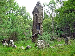 Battle of Corrichie MonumentMonument · 2.0 mi
More archaeology and monuments in Aberdeenshire · All of Aberdeenshire

What do you know about this place?Tap to add a comment or ask a question