Places near here
Photo credits
- C O'Flanagan, Geograph · CC BY-SA 2.0
- jwd, Geograph · CC BY-SA 2.0
- Offdaw, Wikimedia Commons · CC BY-SA 4.0
- C O'Flanagan, Wikimedia Commons · CC BY-SA 2.0
- Kieran Campbell, Geograph · CC BY-SA 2.0
- Zairon, Wikimedia Commons · CC BY 4.0
- SeoR, Wikimedia Commons · CC BY-SA 4.0
- Sitomon, Wikimedia Commons · CC BY-SA 2.0
 Westown HouseCastle, tower house · 1070 yd
Explorer Tom Westown House in Westown is an eighteenth-century mansion that swallowed a tower house whole just to feel more important at dinner parties. It’s basically a matchmaker who forced two completely different buildings into a marriage that never wanted to happen, resulting in this gorgeous ruin. Have a chat with it, nobody's watching.
 mill (water)1372 yd
Explorer Tom A water mill in Westown built in 1720 that has been in ruins since 1934, which is a long time to be messy. The wind keeps picking on it because it’s jealous the river gets all the attention. Pop by and tell it it's looking well, even if it’s just rubble now.
 Catholic Church of the Nativity of Our LadyChurch/chapel · 1390 yd
Explorer Tom Catholic Church of the Nativity of Our Lady in Westown is shaped like a T, which is weird for a church. Dated 1821, it’s got obelisk pinnacles on the corners. Look cool while you photograph it!
 Séamus EnnisStatue · 1508 yd
Explorer Tom Séamus Ennis has a hidden treasure buried under his feet that is definitely a biscuit tin containing three stale digestive biscuits and a letter from his agent about unpaid invoices. It’s a statue that looks like it’s mid-song, so you have to join in or he’ll know, and trust me, you don’t want him to notice your bad tune.
 Seamus Ennis Cultural CentreMemorial · 1510 yd
Explorer Tom Seamus Ennis Cultural Centre in County Dublin gave up music for Lent to prove a point, then immediately regretted it when the silence got too loud. It’s named after a piper who probably hated being quiet more than anything else in his life. Go on a wet day, it suits the mood.
 Passage tomb in FourknocksPassage tomb · 1.1 mi
Explorer Tom Passage tomb in Fourknocks is a big deal, with a cruciform chamber that looks like a stone crossroads. If it introduced itself to a stranger, it’d say: 'I’m old, I’m deep, and I’ve got three recesses for you to get lost in.' It’s the VIP section of the prehistoric underground club. Perfect detour when the satnav has a meltdown.
 Passage tomb art in FourknocksPassage tomb art · 1.1 mi
Explorer Tom Passage tomb art in Fourknocks is covered in spirals that look like they were drawn by a drunk with a compass. If it could review its visitors, it’d say: 'Too many people touching the walls, not enough appreciation for the squiggles.' It’s basically stone graffiti from the world’s most committed artist. Pop by and tell it it's looking well.
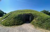 FourknocksPassage tomb · 1.4 mi
Explorer Tom Fourknocks is a passage tomb that probably has a ridiculous smuggling story attached to it, involving smugglers trying to hide barrels of whiskey inside the stones themselves. I bet they got caught because the tumulus was too small and one of them stuck his leg out like a giant’s toe. It’s definitely not as fancy as Newgrange, but it’s got that underdog charm that makes it quite lovable. Bring a f
 KnockbrackMountain / peak · 2.3 mi
Explorer Tom Knockbrack claims to be best friends with a famous actor who gets lost in the woods every time he visits for a shoot. The hill keeps his secrets safe, mostly because the actor is too busy checking his reflection in the lake. Spot the oldest stone and give it a name.
 Hollywood GreatMountain / peak · 2.7 mi
Explorer Tom Hollywood Great has a hidden tunnel to the nearest pub, according to local legend, which is exactly the kind of lie you tell when your feet are sore. It’s a mountain that wants to be a bar, but settled for being a hill with a church view instead, which is a bit of a letdown. Go on, count the windows and get it wrong like I did.
 Gormanston CastleCastle · 4.6 mi
Explorer Tom Gormanston Castle has this shortcut that isn't actually a shortcut, just a very long walk in a circle designed to confuse you. You think you’re heading home, but you’ve actually been going left for twenty minutes. It’s architectural gaslighting at its finest, and I absolutely love it. Make up your own legend and I'll swear it's true.
 European Yew4.6 mi
Explorer Tom Another European Yew in County Meath, claiming an imaginary twin across the sea is jealous of its looks. It’s basically a tree with a big ego and no filter. Grand place for a sulk or a snog, your call.
More historic places in County Dublin · All of County Dublin

What do you know about this place?Tap to add a comment or ask a question