What is recorded here
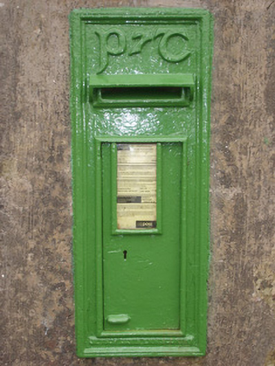
Wall-mounted cast-iron post box, erected c. 1940, with raised 'P&T' monogram in Gaelic script to head and with foundry mark to base reading ‘Jessop Davis, Enniscorthy’. Still in use. Set into rendered gate pier adjacent to site of Croagh Post Office, now demolished. Located adjacent to road in the rural landscape to…
Read the whole record
From the Buildings of Ireland (National Inventory of Architectural Heritage) record 40909212
Places near here
Photo credits
- louise price, Geograph · CC BY-SA 2.0
- louise price, Geograph · Creative Commons Attribution-ShareAlike 2.0
- louise price, Wikimedia Commons · CC BY-SA 2.0
- C Michael Hogan, Wikimedia Commons · CC BY-SA 2.0
- Ronnie Nijboer, Wikimedia Commons · CC0
- EecherplazGinkgo06.jpg : Cayambe derivative work: Ginkgotree ( talk ), Wikimedia Commons · CC BY-SA 3.0
- Kenneth Allen, Wikimedia Commons · CC BY-SA 2.0
- Kenneth Allen, Geograph · CC BY-SA 2.0
- Andreas F. Borchert, Wikimedia Commons · CC BY-SA 4.0
 post box2.0 mi
Explorer Tom Post box in Tullinteane has a raised 'VR' cipher and crown on its head. Installed c. 1890, it feels like a very serious royal guard for a tiny pile of letters! I wonder if Queen Victoria ever checked if the mail was actually going anywhere?
 Drumlaghtafin HillMountain / peak · 2.2 mi
Explorer Tom Drumlaghtafin Hill sits quietly between Leagans Hill and the Gortnalagan townland, keeping its access details firmly under wraps. The name is such a mouthful that I suspect it’s just trying to trip up anyone brave enough to attempt a pronunciation challenge without a map.
 Multins BridgeBridge · 2.3 mi
Explorer Tom Multins Bridge has V-shaped stone teeth on its north side, built around 1870. They look like a giant’s collarbone poking out of the river. I wonder if they actually stop the Oily River from hugging the bridge too tightly.
 Killin HillMountain / peak · 2.6 mi
Explorer Tom Killin Hill sits in County Donegal, recorded as a peak with access details that remain completely unknown. The caption mentions it is three kilometres from Frosses, which makes me wonder if the hill is just hiding behind its neighbour to avoid being found.
 Carraduffy / Killin Court TombCourt tomb · 2.7 mi
Explorer Tom Carraduffy / Killin Court Tomb is mostly a grassy hump with one solitary upright stone standing guard. The rest was demolished long ago, but old maps called it a Giant's Grave or even a friars' house. It’s a bit of a letdown now, but that lone slab makes you wonder what the full structure used to look like.
 Cashel Town Wedge TombsWedge tomb · 2.9 mi
Explorer Tom Cashel Town Wedge Tombs are unique because three galleries sit side-by-side in a single circular kerb. One roofstone is four metres long, and locals once found giant human bones here, which is either brilliant or terrifying.
 Wych Elm3.8 mi
Explorer Tom This impressive Wych Elm stands in Donegal, and you might need permission to get a great photo.
 Ginkgo3.9 mi
Explorer Tom This unique Ginkgo in County Donegal is a rare find, so check if you need permission first.
 Killaghtee Old Church GraveyardGraveyard · 4.4 mi
Explorer Tom Killaghtee Old Church Graveyard sits beside the old church; inside the graveyard, southwest of that church, the survey records a cross-inscribed slab. The Civil Survey called the church 'in reparation', and it remained in use until 1826. I like how one small mapped area holds separate records for the graveyard, church and stone.
 Tara HotelHotel · 5.4 mi
Explorer Tom Tara Hotel in Killybegs on Main Street probably has a view of the sea and some very tired fishermen. It’s the kind of place where the Wi-Fi is slow but the stories are fast.
 MellysRestaurant · 5.4 mi
Explorer Tom Mellys in Killybegs serves fish and chips, which is basically a hug from the sea. Wrap it tight so the salt doesn’t ruin your phone case.
 Cat CastleCastle, tower house · 5.9 mi
Explorer Tom Cat Castle is named after St. Catherine, but really it’s just a tiny stone corner standing on a hill above Killybegs Harbour. It’s been shrinking since 1355, and now only a 3-metre wall survives. It’s a bit pathetic, sure, but looking out over the harbour makes you wonder what that bishop’s manor looked like when it was whole.
More historic places in County Donegal · All of County Donegal

What do you know about this place?Tap to add a comment or ask a question