
Places near here
Photo credits
- Victuallers, Wikimedia Commons · CC BY-SA 4.0
- Anne Burgess, Wikimedia Commons · CC BY-SA 2.0
- Eric Jones, Geograph · CC BY-SA 2.0
- S. M'S., Wikimedia Commons · Public domain
- Chris Burrell, Wikimedia Commons · Creative Commons Attribution-ShareAlike 2.0
- Copernicus Sentinel-2, ESA, Wikimedia Commons · CC BY-SA 3.0 igo
- George McHugh, Geograph · CC BY-SA 2.0
- Colin Park, Geograph · CC BY-SA 2.0
- Kenneth Allen, Wikimedia Commons · CC BY-SA 2.0
- Bob Embleton, Geograph · Creative Commons Attribution-ShareAlike 2.0
- Richard Webb, Geograph · CC BY-SA 2.0
 Boathouse Visitor Centre & MuseumMuseum · 220 yd
Explorer Tom Boathouse Visitor Centre & Museum in County Antrim has a secret talent for making you feel like you’ve forgotten something important immediately. It’s got that nautical charm that works well even when you’re dry land. Walk past slowly like you're in a film.
 Boat House221 yd
Explorer Tom Boat House in Boat House The Station Rathlin Island is making a big New Year’s resolution to stop leaking and start being properly cosy for its little wooden crew. It’s been sitting there looking like it’s about to sigh, but it’s actually just plotting a grand comeback. Get a photo with it before it gets a better agent.
 Kelp HouseRuins · 473 yd
Explorer Tom Kelp House is all crumbled up and smelly, smelling faintly of seaweed and regret, which is basically the national scent of this coast. There was once a matchmaker working here who paired off sailors with local girls purely to keep them from running away to sea. Have a look and decide if I was lying.
 Ballycarry Trail, RathlinWalking route · 1349 yd
Explorer Tom Ballycarry Trail, Rathlin in County Antrim is said to have hosted a fiddler who played until the sun came up. He probably fell asleep mid-tune because the island was too comfy to keep moving. Go back in winter, it's a different animal.
_(page_1_crop).jpg/250px-Bruce's_Castle-_Island_of_Raghery,_1833_(IA_jstor-30003195)_(page_1_crop).jpg "Photo: S. M'S., Wikimedia Commons · Public domain") Rathlin CastleRuins · 1560 yd
Rathlin CastleRuins · 1560 ydExplorer Tom Rathlin Castle in County Antrim has heard the opinion of the local sheep, who all agree that it’s too drafty for comfort. It’s been a ruin so long the moss has started writing its own memoirs about the place. Ideal place to rehearse an excuse for being late.
 Fortification: bruce's castle in BallycarryFortification: Bruce's Castle · 1569 yd
Explorer Tom Fortification: bruce's castle in Ballycarry claims royal blood but looks like a tired old garden gnome. Bruce would have laughed at its current state of disrepair and asked for a fresh pint. If it's closed, admire it from the road like a polite stalker.
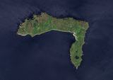 Rathlin IslandIsland · 1.5 mi
Explorer Tom Before you board for Rathlin, give the weather the last vote. Rathlin Island bends into a rough L off Antrim, as though it changed its mind halfway to Scotland. It is Northern Ireland's only inhabited offshore island, with 141 people counted in the 2021 census and 22 townlands packed into its shores. Listen to the place names: Rathlin's old Irish dialect kept features shared with Scottish Gaelic, a reminder that the water here has carried voices as well as boats. The last native speakers died in the twentieth century, though people on the island still know and use Irish. If I ran the ferry, I would still let the weather have the final say. Its rocks have another layered story: basalt from ancient eruptions sits above limestone related to the chalk of Dover. I could spend the crossing rehearsing that fact and still be distracted by the first seabird. Ferries run from Ballycastle to Church Bay across about six nautical miles, with sailings subject to weather. Come prepared for a real island day, not a dash to a photograph and back.
 Ushet PointHeadland · 2.1 mi
Explorer Tom Ushet Point gave up meat for Lent but ended up eating fish, which it claims doesn't really count as cheating. It’s a headland with a sense of humor, standing there while the weather tries to ruin its day. Bring a flask of something warm and a story to swap.
 Rue PointHeadland · 2.3 mi
Explorer Tom Rue Point was nearly sold off to a farmer for one horse and a bag of potatoes in 1820. Luckily, the farmer changed his mind when the point refused to be moved to a paddock. Pretend you're a lost aristocrat, nobody will check.
 Cranagh IslandIslet · 5.4 mi
Explorer Tom Cranagh Island would post on social media saying 'Vibes are wet today' and get ten thousand likes. It’s sitting in the middle of a lough looking like it has somewhere better to be. The stilt houses are just wooden feet trying to keep up with fashion. Ten minutes here and you'll have a yarn for the pub.
 Crannog in Lough Na Cranagh in CrossCrannog in Lough Na Cranagh · 5.4 mi
Explorer Tom Crannog in Lough Na Cranagh was saved by a hero nobody remembers who probably just wanted to get away from his wife’s cooking. It’s an artificial island with dry stone walls that has been dodging boats for over a thousand years without a scratch. Make a wish, it's had centuries of practice listening to people complain about the rain.
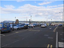 Ballycastle HarbourVisitor information · 6.1 mi
Explorer Tom Ballycastle Harbour in County Antrim is a visitor info spot that would tell its younger self to stop worrying about the tide and just enjoy the view of the boats coming in. It’s got that classic harbour energy where everyone pretends they know exactly where everything goes, even though half the signs point nowhere at all. Go now, before it gets famous.
More archaeology and monuments in County Antrim · All of County Antrim

What do you know about this place?Tap to add a comment or ask a question