
Places near here
Photo credits
- Eric Jones, Geograph · Creative Commons Attribution-ShareAlike 2.0
- National Inventory of Architectural Heritage
- Kieran Campbell, Geograph · Creative Commons Attribution-ShareAlike 2.0
- EecherplazGinkgo06.jpg : Cayambe derivative work: Ginkgotree ( talk ), Wikimedia Commons · CC BY-SA 3.0
- Picture: Ireland In Ruins
- Mike Searle, Wikimedia Commons · CC BY-SA 2.0
- Eric Jones, Wikimedia Commons · CC BY-SA 2.0
- Jeanne dArc at English Wikipedia, Wikimedia Commons · CC BY-SA 3.0
- Sitomon, Wikimedia Commons · CC BY-SA 2.0
- Andreas F. Borchert, Wikimedia Commons · CC BY-SA 4.0
- Robin Pollard, Wikimedia Commons · CC BY 3.0
 Saint Joseph's Catholic ChurchChurch/chapel · 304 yd
Explorer Tom Saint Joseph’s Church in Tevrin has had so many names that it gave up trying to remember them all and just settled on 'The One With The Stone Windows'. It looks like it was built by someone who wanted to be fancy but ran out of money halfway through the budget. If you hear a choir humming from inside, don’t answer; it’s just the wind playing with the
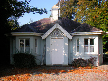 Clondrisse HouseGate lodge · 1570 yd
Explorer Tom Clondrisse House gate lodge has a ghost living in the bay window who is too lazy to haunt anyone properly, preferring to nap on the Gothic Revival fanlight instead. It’s got canted windows and decorative bargeboards that look like they were designed by someone who really loves pointy things. Wave at the sleepy spirit.
 Church of Saint John the Baptist (Rathconnell)Church/chapel · 1587 yd
Explorer Tom Saint John the Baptist would win the county fair for best in show, even with its spire slightly leaning like it’s tired. It’s got that delicate limestone look that says 'I cost money but also caused arguments.' Just picture it standing on a stage, holding a trophy made of old stones.
 Fairy fort / earthen ringfort in ReynellaFairy fort / earthen ringfort · 1729 yd
Explorer Tom Fairy fort / earthen ringfort in Reynella thinks the local sheep are just overgrown dogs that haven’t learned to bark yet. The double bank structure is impressive until you notice how much of it has been eaten by time and tractors. Linger, it's not going anywhere and neither should you.
 Ginkgo1.4 mi
Explorer Tom Ginkgo in County Westmeath has a favourite song that is just the wind rustling through its fan-shaped leaves in a very rhythmic way. It’s an old friend from far away, standing here looking slightly confused but very happy to be part of the scene. Have a nosey, politely.
 Taghmon CastleCastle, tower house · 3.7 mi
Explorer Tom Taghmon Castle would win any county fair for 'Best Dressed Ruin' without breaking a sweat. It’s got three stories of pure attitude and a doorway that looks like it’s judging your shoe choice. Go on a wet day, it suits the mood.
_-_geograph.org.uk_-_2494736.jpg/250px-Castles_of_Leinster,_Martinstown,_Westmeath_(2)_-_geograph.org.uk_-_2494736.jpg "Photo: Mike Searle, Wikimedia Commons · CC BY-SA 2.0") Martinstown Castle in RuinsCastle, tower house · 4.8 mi
Martinstown Castle in RuinsCastle, tower house · 4.8 miExplorer Tom Martinstown Castle in Ruins is playing hard to get on that rock outcrop. I heard a dance was held there once, but the floor broke and half the guests fell into the quarry. Bring a coin for luck and keep it in your pocket.
 Delvin CastleVisitor attraction · 5.2 mi
Explorer Tom Delvin Castle has been locked in a bitter, centuries-long feud with the rain, and honestly, the castle is winning. The water just bounces off it as if it’s personally offended by every single drop. Bring a flask of something warm and a story to swap.
 KnockeyonMountain / peak · 5.6 mi
Explorer Tom Knockeyon hates visitors who wear bright yellow because it reminds it of the time a pigeon got stuck in its moss. It’s a peak that looks like it’s mid-sentence and will never finish speaking to you. Take a mate and argue about what it was for.
 European Yew8.4 mi
Explorer Tom European Yew in County Westmeath has a family tree that is mostly made up, which fits perfectly with how I tell my stories around campfires. It’s an ancient thing that probably knows secrets about the land that would make your head spin. Go on, count the windows and get it wrong like I did.
 Font (present location) in TowlaghtFont (present location) · 11 mi
Explorer Tom Font in Towlaght was moved from an old church to St Finian's in 1991. It’s carved with biblical scenes and looks like it has seen better days. It's free, it's odd, what more do you want?
.jpg/250px-Croppies_Grave_Clonard_-_panoramio_(1).jpg "Photo: Robin Pollard, Wikimedia Commons · CC BY 3.0") Croppies' GraveMemorial · 12 mi
Croppies' GraveMemorial · 12 miExplorer Tom Croppies' Grave marks where rebels fell, and someone wrote a terrible poem about it that rhymed 'blood' with 'mud'. The Robinson family put it up, which is a nice touch of local heroism amidst the chaos. Go now, before it gets famous and starts charging entry fees.
More archaeology and monuments in County Westmeath · All of County Westmeath

What do you know about this place?Tap to add a comment or ask a question