Places near here
Photo credits
- National Inventory of Architectural Heritage
- Willow, Wikimedia Commons · CC BY 2.5
- Steve & Jemma Copley on Flickr, Wikimedia Commons · CC BY-SA 2.0
- N Chadwick, Wikimedia Commons · CC BY-SA 2.0
- Illustrator not named; The Dublin Penny Journal (1835), public scan from Internet Archive and JSTOR, Wikimedia Commons · Public domain
- Marathon, Wikimedia Commons · CC BY-SA 2.0
- Oliver Dixon, Wikimedia Commons · CC BY-SA 2.0
- Colin Park, Geograph · CC BY-SA 2.0
Explorer Tom Castle in Millcastle is sitting next to a dried-up mill race like it’s ignoring its ex. If it had a dating profile, it’d say: 'Tall, handsome, and currently unavailable due to structural issues.' Wave at the cows, they're the real locals.
CrossCross, Wayside cross · 771 ydExplorer Tom Site of Church in Knockmant is sitting on top of a hill like it owns the view. It’s got a castle and a ringfort for neighbours, which is quite the exclusive postcode. A good place to forget your phone for ten minutes.
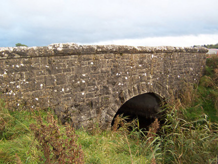 Stonestown BridgeBridge · 872 yd
Explorer Tom Stonestown Bridge would have 'I held up this weight so you don’t have to' on its tombstone. It was built by the Board of Works and looks like it’s ready for one more heavy truck before it sighs. Cross carefully and thank it politely.
 Gilbertstown HouseMiller's house · 1241 yd
Explorer Tom Gilbertstown House in Clongowly would bring a bag of flour and a grumpy attitude to any party it attended. It was a miller's house, so it’s used to being covered in dust and having its fittings stolen. Check out that cut limestone doorcase from the street!
 European ash1565 yd
Explorer Tom European ash in County Westmeath was saved by a hero nobody remembers, who probably just tripped over the roots and accidentally pruned it into shape. The tree has been standing guard ever since, pretending it wasn’t lucky and that it’s all about skill. Stand on the spot and imagine the gossip it's heard.
 Silver Fir1.5 mi
Explorer Tom Another Silver Fir in County Westmeath is posting selfies of its own leaves because it thinks it’s the most photogenic tree on the block. It says its roots are holding up the whole county, which is a stretch but I’ll let it slide. Tell the next person you meet it's haunted by old wood spirits. It might be.
 North West GateVisitor attraction · 3.0 mi
Explorer Tom The North West Gate is haunted by a tragic love story that went horribly wrong right next to it. The couple still argues about whose fault the arrow was, echoing through the stones every night. Go in good boots and better humour.
_(page_1_crop).jpg/250px-Fore_Abbey,_County_Westmeath,_1835_(IA_jstor-30004138)_(page_1_crop).jpg "Photo: Illustrator not named; The Dublin Penny Journal (1835), public scan from Internet Archive and JSTOR, Wikimedia Commons · Public domain") Fore AbbeyHeritage attraction · 3.0 mi
Fore AbbeyHeritage attraction · 3.0 miExplorer Tom Fore Abbey is refusing to fall down because it has excellent structural pride. It just stands there looking smug while the rest of the world crumbles around it. Spot the oldest stone and give it a name.
 Font in ForeFont · 3.0 mi
Explorer Tom Font in Fore would tell the place that replaced it to stop hogging all the attention at the door. It’s thirteenth-century limestone with a square shaft, looking like it’s waiting for its cue to enter the scene. Bring your nan, she'll know more than me about who did what.
 Ben of ForeMountain / peak · 3.6 mi
Explorer Tom Ben of Fore has a tunnel right through the middle that leads directly to the nearest pub, I’m certain. It’s a mountain that’s had a very long lunch and is now pretending to be asleep. A proper spot for a flask of tea and a big think.
 Mullaghmeen Red WalkWalking route · 3.7 mi
Explorer Tom The Mullaghmeen Red Walk hosted a dance that went so far that someone ended up married to a tree. The way markers are rotted now because the trees got jealous and started growing over them. Tell me if the gossip I made up is true.
 Mullaghmeen White WalkWalking route · 3.8 mi
Explorer Tom The Mullaghmeen White Walk has a secret it would tell after a few pints, but it’s too shy to say it out loud. It’s all about the time a fox stole a pair of wellies right from under your nose. Bring someone who'll believe anything.
More archaeology and monuments in County Westmeath · All of County Westmeath

What do you know about this place?Tap to add a comment or ask a question