
What is recorded here
From the Irish Caves Database, University of Bristol Spelæological Society record 2066
Places near here
Photo credits
- louise price, Wikimedia Commons · CC BY-SA 2.0
- Joseph Mischyshyn, Wikimedia Commons · CC BY-SA 2.0
- Maker not stated on source page, www.istockphoto.com
- Golfing in Ireland; photographer not stated, Source publisher
- Sue Mischyshyn, Wikimedia Commons · CC BY-SA 2.0
- Maker not stated on source page, ph.pinterest.com
- Maker not stated on source page, en.wikipedia.org
- Maker not stated on source page, www.tripadvisor.co.za
- National Inventory of Architectural Heritage
- Eric Jones, Geograph · Creative Commons Attribution-ShareAlike 2.0
- Maker not stated on source page, www.tripadvisor.com.au
 Cliffs of OweyPublicly named cliff or headland · 187 yd
Explorer Tom Cliffs of Owey thinks the road leading to it is a personal insult to its majestic stature. It would prefer you arrive…
 UaighIsland · 517 yd
Explorer Tom Uaigh means cave, but Owey Island's bigger surprise is how much life its small Donegal outline once held. Around 120…
 Megalithic tomb in UaighMegalithic tomb · 519 yd
Explorer Tom The Megalithic tomb in Uaigh is basically a two-stone argument about whether a Giant ever actually slept here. Borlase…
 Cruit Island Golf ClubGolf course · 1.2 mi
 An ChruitIsland · 2.2 mi
Explorer Tom An Chruit, better known to many visitors as Cruit Island, is a Donegal island you reach by a bridge, then discover that…
 Holy well in An Chruit Uachtarach,an Chruit ÍochtarachHoly well · 2.4 mi
Explorer Tom Holy well in An Chruit Uachtarach, An Chruit Íochtarach is one of several simple pits dug right into the sand. It’s a…
 St. Bridget's WellsSpring · 2.6 mi
Explorer Tom St. Bridget's Wells in County Donegal is definitely the spot where a priest lost a bet over who could drink the most…
 Cruit Island GraveyardCemetery · 2.6 mi
Explorer Tom Cruit Island Graveyard has a favourite song that is just the sound of the waves crashing against the rocks at high…
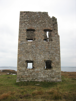 Mullaghderg Signal TowerSignal tower · 3.0 mi
Explorer Tom Mullaghderg Signal Tower was built in 1806 to help watch for a possible French invasion. The old survey found it…
 Saint Mary's Catholic ChurchChurch/chapel · 3.5 mi
Explorer Tom Saint Mary's Catholic Church in Belcruit would order a massive chipper with extra gravy if it ever hit the pub. It’s…
 Mapped cemeteryCemetery · 3.6 mi
Explorer Tom “Mapped cemetery” in County Donegal was designed by a mother-in-law who wanted every headstone to be exactly three…
 Carey's Viking House HotelHotel · 3.8 mi
Explorer Tom Carey’s Viking House Hotel claims Vikings lived here, which is hilarious considering they were busy raiding France at…
More caves in County Donegal · All of County Donegal

What do you know about this place?Tap to add a comment or ask a question