Places near here
Photo credits
- National Inventory of Architectural Heritage
- Brian Shaw, Wikimedia Commons · CC BY-SA 2.0
- Eric Jones, Wikimedia Commons · CC BY-SA 2.0
- Mike Searle, Wikimedia Commons · CC BY-SA 2.0
- Sitomon, Wikimedia Commons · CC BY-SA 2.0
- surrealpenguin, Wikimedia Commons · CC BY-SA 2.0
- Kieran Campbell, Geograph · Creative Commons Attribution-ShareAlike 2.0
- John M, Wikimedia Commons · CC BY-SA 2.0
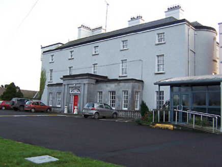 South HillCountry house, house · 608 yd
Explorer Tom South Hill in Southhill has an escape plan from its first owner that involved running away on a donkey wearing a wig. The Doric porch is crisp limestone, which is funny because the rest of the place seems like it’s trying to hide behind modern additions. Spot the original house hiding among all that new stuff!
Man-made underground passage in CastletowndelvinMan-made underground passage · 820 ydExplorer Tom Man-made underground passage in Castletowndelvin has strict visitor rules: no shouting, no touching, and absolutely no asking how it got there. It was built by people who really hated sunlight and good conversation. Best enjoyed with a bag of chips and no plans.
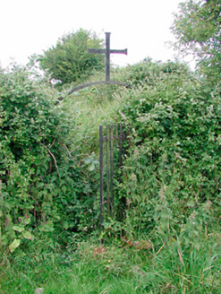 graveyard/cemetery929 yd
Explorer Tom The graveyard in Castletowndelvin thinks the road leading to it is personally rude, so it has arranged its headstones to point away from the traffic. It’s where the last workhouse in Ireland put its residents to rest, which is a bit of a grand final for poverty. Look at it respectfully but don’t let it scare you.
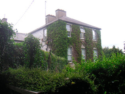 BelmontRectory/glebe/vicarage/curate's house · 932 yd
Explorer Tom Belmont in Castletowndelvin has a shortcut that isn't actually a shortcut at all! It was a rectory, so it’s got that 'very serious priest lives here' energy. The gate posts are carved beautifully, which is very fancy for a vicarage. Do the grounds feel like they’re hiding a secret path? Explore from the outside only!
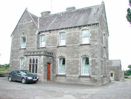 Catholic Church of the AssumptionPresbytery/parochial/curate's house · 1027 yd
Explorer Tom Castletowndelvin’s parochial house is built from limestone so fancy it probably has its own personal butler and a secret biscuit tin full of gold coins. The texture is so interesting that if you touch it, it might sue you for lack of appreciation. If you hear a crunch inside, it’s definitely just crumbs, not treasure.
 CastleCastle, tower house · 1106 yd
Explorer Tom Castletowndelvin Castle is a tower house that thinks it’s a hall-house, which is a bit like wearing a tuxedo to the beach. It’s got corner towers that look smug enough to charge rent. Stand where the owner stood and practise looking smug.
 Delvin CastleVisitor attraction · 1107 yd
Explorer Tom Delvin Castle has been locked in a bitter, centuries-long feud with the rain, and honestly, the castle is winning. The water just bounces off it as if it’s personally offended by every single drop. Bring a flask of something warm and a story to swap.
_-_geograph.org.uk_-_2494736.jpg/250px-Castles_of_Leinster,_Martinstown,_Westmeath_(2)_-_geograph.org.uk_-_2494736.jpg "Photo: Mike Searle, Wikimedia Commons · CC BY-SA 2.0") Martinstown Castle in RuinsCastle, tower house · 1.5 mi
Martinstown Castle in RuinsCastle, tower house · 1.5 miExplorer Tom Martinstown Castle in Ruins is playing hard to get on that rock outcrop. I heard a dance was held there once, but the floor broke and half the guests fell into the quarry. Bring a coin for luck and keep it in your pocket.
 European Yew2.7 mi
Explorer Tom European Yew in County Westmeath has a family tree that is mostly made up, which fits perfectly with how I tell my stories around campfires. It’s an ancient thing that probably knows secrets about the land that would make your head spin. Go on, count the windows and get it wrong like I did.
 Persian Walnut2.8 mi
Explorer Tom Persian Walnut in County Westmeath wants 'Lived Large' on its tombstone because it has been producing some seriously impressive nuts for decades without complaint. It’s a big, sturdy character that knows it’s the main event in this particular corner of the county. Bring a friend who talks too much and let the place shut them up.
 Fairy fort / earthen ringfort in ReynellaFairy fort / earthen ringfort · 4.7 mi
Explorer Tom Fairy fort / earthen ringfort in Reynella thinks the local sheep are just overgrown dogs that haven’t learned to bark yet. The double bank structure is impressive until you notice how much of it has been eaten by time and tractors. Linger, it's not going anywhere and neither should you.
 LoughcrewMegalithic tomb cemetery · 9.2 mi
Explorer Tom Loughcrew is a megalithic tomb cemetery on Slieve na Calliagh, which sounds like a place where the stones are just hanging out and judging your fashion choices. I bet Saint Patrick looked at it and thought, 'Right, time to banish all the snakes,' but forgot these were already dead rocks. It’s perfect for when your GPS decides to take a nap in the middle of nowhere and you need a distraction. P
More archaeology and monuments in County Westmeath · All of County Westmeath

What do you know about this place?Tap to add a comment or ask a question