Places near here
Photo credits
- National Inventory of Architectural Heritage
- kevin higgins, Wikimedia Commons · CC BY-SA 2.0
- Dalenevada, Wikimedia Commons · CC BY-SA 4.0
- Mike Searle, Geograph · CC BY-SA 2.0
- Willow, Wikimedia Commons · CC BY 2.5
- JP, Geograph · CC BY-SA 2.0
- Algirdas at Lithuanian Wikipedia, Wikimedia Commons · Public domain
- Kieran Campbell, Wikimedia Commons · CC BY-SA 2.0
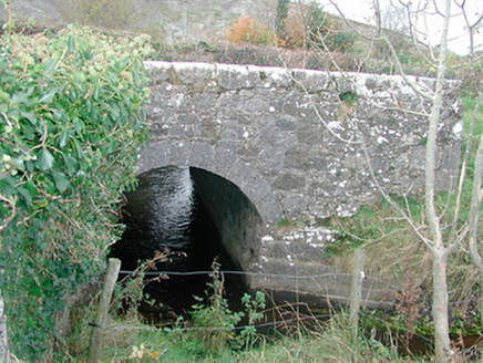 bridge699 yd
Explorer Tom Bridge in Ballynagall is a small stone bridge with a distinct kink in its parapet wall, probably because it got into an argument with a road junction. The cut stone voussoirs show some serious craftsmanship from the Grand Juries who liked their roads smooth and their bridges straight-ish. It’s got character, which is more than I can say for my left shoe.
 New Forest HouseCountry house · 1300 yd
Explorer Tom New Forest House in Higginstown employed a matchmaker who specialized in pairing up guests with their own bad decisions during dinner parties. The breakfront is centered perfectly, which suggests the architect liked things balanced and maybe a little bit smug about it. Listen for the sound of broken hearts!
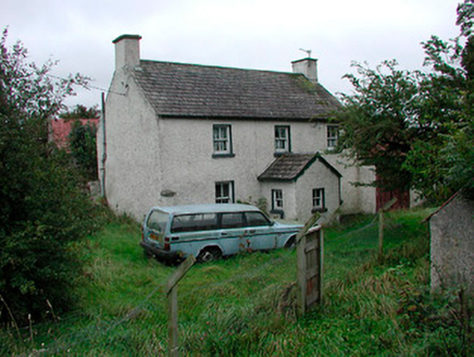 farm house1720 yd
Explorer Tom Farm house in Knockmore has strong opinions about modern buildings, mostly involving the word 'ugly' and a lot of pointing. It’s one of the few surviving vernacular farms that hasn’t been ruined by someone adding a glass extension. Nod respectfully to its wrought-iron gate or it’ll judge your boots.
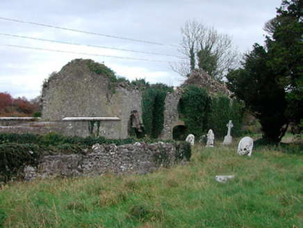 church/chapel1.0 mi
Explorer Tom Church or chapel in Rahinashurock has an unlikely celebrity friend who is basically everyone’s dead grandmother. The graveyard is full of headstones so fancy they’re probably jealous of the church itself. It’s got that picturesque ruin vibe that makes you feel like you’ve wandered into a very old, very serious dream.
 St. Columbkilles CrossCross, High cross · 5.1 mi
Explorer Tom St. Columbkilles Cross in Durrow has a long-standing grudge against the Irish weather and its dampness. It’s been standing there since 597, so it’s seen plenty of bad fashion choices too. Have a sandwich here and call it a heritage lunch.
 Durrow High CrossVisitor attraction · 5.1 mi
Explorer Tom Durrow High Cross is absolutely sick of being asked if it’s still standing, like it’s some kind of fragile antique that might tip over if the wind gets too cheeky. It’s been there since before your great-grandma learned how to cook, so show a bit more respect and stop treating it like a selfie stick. Bring some sandwiches, because those gulls down here are basically starving artists waiting for an
 CrossCross, High cross · 5.1 mi
Explorer Tom Cross in Durrow Demesne is just a shaft fragment cemented into the wall like it’s giving up. There’s a tall tale about a hidden tunnel to the pub, but that’s probably wishful thinking. Stick around for the light changing, it's a show.
 Durrow MoatCastle, motte · 5.1 mi
Explorer Tom Durrow Moat is deeply suspicious of the postman and hides its head under the earth. Hugh de Lacy died there, so don't get too comfortable. Tell it a joke, it's been a long time since anyone did.
 European ash6.5 mi
Explorer Tom This European ash in County Offaly is hiding a scandal about which branch grew first, and nobody agrees. It keeps the truth locked up tight while the leaves rustle with gossip. Go back in winter, it's a different animal when it’s all bare and honest.
 Grand Canal WayWalking route · 7.4 mi
Explorer Tom Grand Canal Way is handling its nosy neighbors by just keeping its eyes on the water, pretending it doesn’t see anyone peering over the railings asking questions. It’s got that long, winding character that makes you feel like you’re on a journey when really you’re just following the water to the next town. Bring your curiosity and leave with a better story
 Pedunculate Oak8.6 mi
Explorer Tom Pedunculate Oak in County Offaly is currently involved in a fierce fairy dispute over parking rights on its lower branches. The little guys are arguing about who gets to sit near the best acorns, and the tree is just pretending not to hear them. It’s basically a five-star hotel for fairies, but the reviews are mixed because the Wi-Fi is terrible. Look for
 Ballycowan CastleCastle · 8.8 mi
Explorer Tom Ballycowan Castle is where a dance in 1589 went too far and someone dropped their hat. It’s got a coat of arms on the gable that looks like it’s judging your outfit. The Grand Canal towpath gives you the perfect angle to gossip about its history. Tell me if the gossip I made up is true.
More archaeology and monuments in County Westmeath · All of County Westmeath

What do you know about this place?Tap to add a comment or ask a question