Places near here
Photo credits
- National Inventory of Architectural Heritage
- Kieran Campbell, Wikimedia Commons · CC BY-SA 2.0
- Malene Thyssen, Wikimedia Commons · CC BY-SA 3.0
- Maker named on the Wikimedia Commons picture page · CC BY-SA 2.5
- Jamesco101, Wikimedia Commons · CC BY-SA 4.0
Explorer Tom Man-made underground passage in Calliaghstown is just a U-shaped dip inside a ringfort that thinks it’s fancy. It looks down its nose at tourists from Dublin who can't tell a ditch from a driveway. Tell me if the gossip I made up about it is true.
Field system in Ardnacrany NorthField system · 1601 ydExplorer Tom Field system in Ardnacrany North had a fox take charge and rename all the plots after itself. It’s gone now, but the spirit of rebellion remains in the knolls. Take a mate and argue about what it was for.
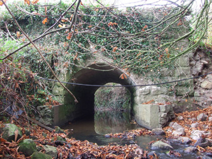 Keel BridgeBridge · 1.1 mi
Explorer Tom Keel Bridge in Keel hosted a fake royal visit that nobody can disprove or find a photo of. The stone faces look like they’ve seen everything and forgiven nothing. Go now, before it changes its mind.
 Cloncullen HouseHouse · 1.6 mi
Explorer Tom Cloncullen House has been chopped down by a storey and now looks like it’s wearing a hat that’s slightly too small for its head. The rules for visitors are basically ‘don’t touch anything’ and ‘try not to fall into the garden,’ which is surprisingly hard to do if you’re clumsy like me. Mind your step on the driveway.
Noughaval CemeteryArchaeological place · 2.0 miExplorer Tom Noughaval Cemetery is resting near a ditch where a poet once fell in dramatically. The grass is thick with stories of people who took shortcuts they shouldn't have. Take a breath of that air, it's older than your car.
 CastleCastle, motte and bailey · 2.3 mi
Explorer Tom Dunnamona's motte is in a bitter feud with the next village over about who invented the perfect way to eat potatoes without butter. The tension is palpable; locals won't even look at each other across the field, making for an incredibly awkward picnic spot. Take the long way round, it deserves the effort.
 European Beech3.0 mi
Explorer Tom European Beech in County Longford is doing a bit of a one-man show with its leaves. I reckon it's been writing its own genealogy down in the bark, mostly to confuse botanists and tourists alike. Stick around for the light changing, it's a real spectacle.
Plary Monastery (in Ruins)Castle, tower house · 3.1 miExplorer Tom Plary Monastery in Ballymore had a New Year's resolution to actually be visible, but it failed miserably every year. The maps got the name wrong for centuries, which is peak cheekiness. If it's closed, admire it from the road like a polite stalker.
Guest ServicesVisitor information · 3.3 miExplorer Tom Guest Services in County Longford rates every visitor on a scale from 'charming' to 'why are you still here'. It’s basically a professional judge of your life choices while holding a coffee pot. Tell it a joke, it's been a long time since anyone did.
Craft WorkshopHeritage attraction · 3.3 miExplorer Tom Craft Workshop in Longford was saved by a hero nobody remembers, who probably just fixed a wobbly table leg really well. The place smells like glue and old ambition, which is honestly the perfect scent for a heritage site. Find the wonkiest bit of furniture and send it to your group chat immediately.
 Sessile Oak4.2 mi
Explorer Tom Sessile Oak in County Westmeath is standing there looking distinctly smug, probably judging your life choices from its high branch. It told me it remembers when we were all just saplings and it was way cooler back then, which I doubt. Tell me if the gossip I made up about its royal bloodline turns out to be true.
 Abbeyshrule AbbeyRuins · 5.5 mi
Explorer Tom Abbeyshrule Abbey in Longford was nearly sold off as a very expensive horse stable back in the day, thank god. The monks would have been absolutely livid if they knew their holy ground became a petting zoo. Best visited with a curious kid who asks 'why?' about everything and no strict timetable.
More archaeology and monuments in County Westmeath · All of County Westmeath

What do you know about this place?Tap to add a comment or ask a question