
Places near here
Photo credits
- National Inventory of Architectural Heritage
- Charles T. G. Clarke, Wikimedia Commons · CC BY-SA 4.0
- Richard Webb, Geograph · CC BY-SA 2.0
- Kmcnamee, Wikimedia Commons · CC BY-SA 4.0
- Gillaween, Wikimedia Commons · CC BY-SA 4.0
- Steve & Jemma Copley on Flickr, Wikimedia Commons · CC BY-SA 2.0
- Oliver Dixon, Wikimedia Commons · CC BY-SA 2.0
- 2ManyCats4Me, Wikimedia Commons · CC0
- Miguel Angel Masegosa Martínez, Wikimedia Commons · CC BY 2.0
 worker's house462 yd
Explorer Tom Worker's house in Correaly, County Westmeath is a pair of modest homes that locals swear will haunt you if you don’t…
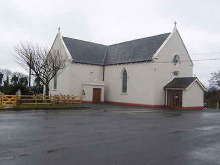 Saint Mary's Catholic ChurchChurch/chapel · 1041 yd
Explorer Tom Saint Mary's Catholic Church in Boyanacalry ended up here because the builder got lost on the way to the next village…
 Coolamber CastleHouse, fortified house · 1.2 mi
Explorer Tom Coolamber Castle House is where Saint Patrick would have said, ‘You’ve got a bit of an ego for a pile of rocks.’…
 CastleCastle, motte · 3.2 mi
Explorer Tom Castle in Russagh handles its nosey neighbours by simply not being there anymore, which is the ultimate…
 Oliver Lynch Park, AbbeylaraGAA ground · 4.1 mi
 Sheela-na-gig in AbbeylaraSheela-na-gig · 4.6 mi
Explorer Tom Sheela-na-gig in Abbeylara has been staring into the void for centuries, and I swear she’s judging your outfit while…
 Silver Fir4.7 mi
Explorer Tom Silver Fir in County Westmeath is so tall it thinks Saint Patrick personally shook its hand, which seems unlikely given…
 Children of Lir: Lough DerravaraghLegend location · 5.1 mi
Explorer Tom Children of Lir: Lough Derravaragh starts with four children becoming swans because Aoife could not bear sharing the…
 Granard MotteMotte-and-bailey castle remains · 5.6 mi
Explorer Tom Granard Motte would describe the 1800s to a teenager as 'basically a long queue for nothing'. It's just a big mound…
 1798 MonumentMonument · 5.6 mi
Explorer Tom The 1798 Monument in Granard uses a Celtic high cross style to tell you about a battle that happened two hundred years…
 Sweet Chestnut5.7 mi
Explorer Tom Sweet Chestnut in County Westmeath has been locked in a bitter feud with the village over who left a half-eaten…
Castletown, Castletown Finea Coole WhitehallGAA ground · 6.2 miMore archaeology and monuments in County Westmeath · All of County Westmeath

What do you know about this place?Tap to add a comment or ask a question