
Places near here
Photo credits
- Kmcnamee, Wikimedia Commons · CC BY-SA 4.0
- National Inventory of Architectural Heritage
Explorer Tom Crannog in Ballynahinch thinks the road to it is a joke, but the island is serious business. Bronze Age wicker huts say…
Partially indicatedFairy fort / earthen ringfort · 1161 ydExplorer Tom Fairy fort or earthen ringfort in Ballybeg would survive a zombie attack by hiding inside its own circular bank and…
Moyally Castle (in Ruins)Bawn · 1161 ydExplorer Tom Moyally Castle Bawn is basically a big wall with a fancy oval bit that used to be a bathroom. The wind keeps picking on…
 Moate All Whites GAA pitchGAA ground · 1433 yd
 Ballinderry HouseCountry house · 1503 yd
Explorer Tom Ballinderry House in Ballinderry is stuck in that awkward phase where it wants to be Tudor Gothic but is actually just…
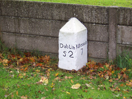 milestone/milepost1508 yd
Explorer Tom Milestone or milepost in Legan holds a fake world record for being the most bored stone on Dublin Road since the…
Bawn in Cartronkeel (clonlonan By.)Bawn · 1.4 miExplorer Tom Bawn in Cartronkeel would bring a half-eaten sandwich and a strong opinion on seating arrangements to any party. It’s…
Moate HillMountain / peak · 1.5 miExplorer Tom Moate Hill would use a lotto win to buy a bigger shadow so it can look more impressive from the air. It’s just a hill…
Charles BianconiMemorial · 1.6 miExplorer Tom Charles Bianconi’s memorial in Westmeath is standing there like it’s waiting for a poet who fell into the ditch nearby…
The Bob Traynor GalleryGallery · 1.7 miExplorer Tom The Bob Traynor Gallery took about forty cups of tea to build, all spilt on the floor. It’s a mess of creativity that…
Tubber GAA pitchGAA ground · 2.0 miDún na Sí Heritage CentreMuseum · 2.2 miExplorer Tom Dún na Sí in Moate puts a farmhouse, a forge and a reconstructed ringfort within one heritage park; that is a lively…
More archaeology and monuments in County Westmeath · All of County Westmeath

What do you know about this place?Tap to add a comment or ask a question