
Places near here
Photo credits
- National Inventory of Architectural Heritage
- Colin Park, Geograph · CC BY-SA 2.0
- Hywel Williams, Geograph · Creative Commons Attribution-ShareAlike 2.0
- Mike Searle, Wikimedia Commons · CC BY-SA 2.0
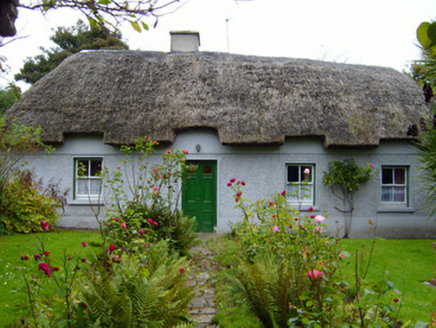 Martin's CottageHouse · 695 yd
Explorer Tom Martin's Cottage in Ballyroe Lower is rolling its eyes at the Dublin tourists who keep asking if it has Wi-Fi or a bathroom. It’s got a thatched roof and sash windows, which basically means 'slow down, ya city slickers.' Wave to it from the roadside and maybe it’ll wave back with a sneer.
Earthwork in Ballinanima (darcy)Earthwork · 875 ydExplorer Tom Earthwork in Ballinanima gave up sugar for Lent but kept its circular shape because it was too lazy to change. It vanished between two maps, which is just lazy surveying really. Ten minutes here and you'll have a yarn for the pub.
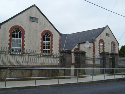 Kilfinnane Girls National SchoolSchool · 1072 yd
Explorer Tom Kilfinnane Girls National School would have made Saint Patrick raise an eyebrow at its brickwork. He liked simpler things, like shamrocks and not having to explain lean-to classrooms to tourists. Look up, the gables are judging you.
Ballyhoura tourist informationVisitor information · 1246 ydExplorer Tom Ballyhoura tourist information in Limerick claims its favourite song is 'The Mountain Goat' because it thinks everyone else is too loud and lacks proper rhythm. It’s got a vibe that says 'stay on the path or regret it later.' Ring your granny and tell her where you are.
Treada Na Ríogh (The Moat), hachuredCastle, motte · 1504 ydExplorer Tom Treada Na Ríogh has an imaginary twin across the sea that keeps waving at it. The moat is basically a giant historical shrug right now on the hilltop. Walk past slowly like you're in a film.
Palatine's RockNamed rock · 1.7 miExplorer Tom Palatine's Rock in County Limerick is hosting an unannounced royal visit that nobody can prove didn't happen. Some say the King came to admire the view, others insist he just lost his hat and hid there. Go in good boots and better humour.
Ballyhoura WayWalking route · 2.0 miExplorer Tom Ballyhoura Way is basically a trail for people who want to feel like explorers but actually just want to trip over rocks. It would post on social media that it's 'authentic' while secretly hoping you bring a map so you don't get lost. Best enjoyed with a bag of chips and no plans.
Ballinvreena LoopVisitor information · 2.4 miExplorer Tom Ballinvreena Loop in Limerick has a prophecy that says whoever walks it backwards will be cursed with eternal hunger for chip butty, which never quite came true. It’s a loop that seems to go on forever, just like my patience. Grand place for a sulk or a snog, your call.
 SlievereaghMountain / peak · 3.3 mi
Explorer Tom Slievereagh has very strong opinions on modern buildings and has been muttering about them since 1890. It thinks that concrete is just rock that gave up on life too early. Ideal spot for a dramatic phone call.
 Seefin Mountain East TopMountain / peak · 4.0 mi
Explorer Tom Seefin Mountain East Top in County Limerick had a brief moment where a fox took charge of the summit and started directing traffic, which was lovely until it left. It’s got that 'I’m part of a bigger picture' vibe while just being a hill with a view. Tell the next person you meet it's haunted. It might be.
 Grave YardGraveyard · 4.5 mi
Explorer Tom Graveyard in Ballingarry refuses to fall down because it’s holding onto its dignity with both hands and refusing to give an inch to decay. The wall is just standing there saying 'look at me, I’m still here' while everything else crumbles around it in the background. Best seen with a hangover and a sausage roll.
 Castle (in ruins)Castle, tower house · 5.2 mi
Explorer Tom Castle in Knocklong East is currently being judged by the local rabbits who think it’s a very overgrown playground that nobody maintains properly. Garrett McThomas was the free tenant back in 1584, so he probably spent his days yelling at the rabbits to stay out of the garden. Find a local and ask them the real story, then come back and tell me.
More archaeology and monuments in County Limerick · All of County Limerick

What do you know about this place?Tap to add a comment or ask a question