Places near here
Photo credits
- Wikimedia Commons contributor · Public domain
- Joe King, Wikimedia Commons · CC BY-SA 3.0
- Riccardo Salvatore Riggi, Wikimedia Commons · CC BY-SA 4.0
- XeresNelro, Wikimedia Commons · CC BY-SA 4.0
- Jan-Herm Janßen, Wikimedia Commons · CC BY-SA 3.0
- 1ivia, Wikimedia Commons · CC BY 2.0
- Pampuco, Wikimedia Commons · CC BY-SA 4.0
- Rafesmar, Wikimedia Commons · CC BY-SA 4.0
- No machine-readable author provided. Haraldius~commonswiki assumed (based on copyright claims)., Wikimedia Commons · CC BY-SA 2.5
- Joseph Mischyshyn, Wikimedia Commons · CC BY-SA 2.0
- The Vicious Chicken of Bristol, Wikimedia Commons · CC BY-SA 4.0
- Oliver Dixon, Wikimedia Commons · CC BY-SA 2.0
 CamaderryMountain / peak · 1070 yd
Explorer Tom Camaderry is pumping water straight through its own gut to power the lights up on Turlough Hill. It’s basically a natural hydro-electric engine that doesn’t even pay rent for the privilege. Make a wish, it's had centuries of practice.
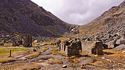 Miners' VillageRuins · 1721 yd
Explorer Tom Miners' Village is hiding a treasure that is definitely just a rusty biscuit tin full of old buttons. The legend says it’s gold, but we all know it’s just someone’s lost lunch from 1920. It's the kind of place that makes a dull Tuesday interesting.
 Turlough HillMountain / peak · 1.3 mi
Explorer Tom Turlough Hill is really just the top of a dam pretending to be a proper mountain peak. A local priest once bet he could name every stone, but the water drowned his confidence. Bring a friend who talks too much and let the place shut them up.
 GlendaloughViewpoint · 1.3 mi
Explorer Tom Glendalough is where a priest lost a bet on whether the lake would freeze, and he still owes for a pint. He’s been hiding there ever since, which explains why it looks so mysterious and full of secrets. Grand place for a sulk or a snog, your call.
 Saint Kevin's BedRuins · 1.4 mi
Explorer Tom Saint Kevin's Bed in County Wicklow started because two lads bet their bikes on who could nap longest on a rock. One woke up with a stone in his shoe, but the legend stuck anyway, proving that laziness can become holy if you wait long enough. Perfect detour when the satnav has a meltdown.
 Poulanass WaterfallWaterfall · 1.7 mi
Explorer Tom Poulanass Waterfall is the shortcut that isn’t a shortcut because you’ll end up climbing over rocks for an hour just to get splashed on the face. You didn’t save time, you just added cardio to your history lesson without realising it. Bring your own legend, I've run out.
 Wicklow GapMountain pass · 1.8 mi
Explorer Tom Wicklow Gap makes crossing mountains look easy because somebody laid a road through the argument. The R756 climbs to about 475 metres between Tonelagee and the Turlough Hill side, linking the country toward Dunlavin with Glendalough. Saint Kevin's Way crosses too, giving walkers a very different pace from my optimistic driving. On an exceptionally clear day, the Welsh mountains can appear across the sea. I would promise that view on demand, but even my cheek cannot order the weather around. The pass is open road and exposed upland, so check conditions, park only where allowed and never wander into traffic for a photograph. Look at the slopes on both sides before heading down. A gap is simply a mountain's way of letting you through on its own terms.
 CloigtheachRound tower · 2.1 mi
Explorer Tom Cloigtheach in Sevenchurches would tell you in a job interview that he has excellent stability and zero need for a desk. He’s thirty metres of pure granite attitude, standing there while the wind tries to push him over. Stand still and listen, the wind tells it better than me.
 Glendalough Round TowerHeritage attraction · 2.1 mi
Explorer Tom Glendalough Round Tower would take its lotto win and buy a really expensive hat to match its ancient style. It’s been standing there long enough to know that fashion is just a suggestion anyway. Practise your Irish on it, it won't correct you, but the wind definitely will.
 G. YardGraveyard · 2.1 mi
Explorer Tom G. Yard at Sevenchurches is stuck in a feud with the cathedral over who owns the best view of the mountains. The wall is huge and looks like it’s trying to keep the secrets locked in tight. A good place to forget your phone for ten minutes.
 Battle of GlenmalureMajor battlefield · 3.5 mi
Explorer Tom The Battle of Glenmalure echoes with the sound of sheep complaining about the mud in 1580. Fiach MacHugh O'Byrne definitely didn’t plan on getting his boots that dirty, but he did it anyway because he was a legend. Leave nothing but footprints and a bad pun.
 Shay Elliott memorialMemorial · 4.2 mi
Explorer Tom Shay Elliott memorial is where a love story went catastrophically wrong next door in 1942. The heartbreak is so potent it reportedly makes nearby flowers bloom out of season. Look up, the best bit is always higher than you think.
More historic places in County Wicklow · All of County Wicklow

What do you know about this place?Tap to add a comment or ask a question