
What is recorded here
North Hirn is a farmstead in Aberdeenshire, Scotland.
From the Historic Environment Scotland record 184848
The historic-place record does not grant public access. Check current conditions and ownership before entering land or a building.
Places near here
Photo credits
- Andrew Wood, Wikimedia Commons · CC BY-SA 2.0
- Stanley Howe, Wikimedia Commons · CC BY-SA 2.0
- Alan Findlay, Wikimedia Commons · CC BY-SA 2.0
- Ballogie, Wikimedia Commons · CC BY-SA 2.0
- Keith Grinsted, Wikimedia Commons · CC BY-SA 2.0
- Colin Smith, Wikimedia Commons · CC BY-SA 2.0
 South HirnFarmhouse, Farmstead · 83 yd
 Hirn TriangleForest · 292 yd
 KilduthieChurch (possible) · 755 yd
 Mill of HirnRig and Furrow (medieval) - (post Medieval) · 831 yd
 Battle of CorrichieBattle · 1290 yd
 Birks Lodge, Boundary StonesBoundary Stone(s) (19th Century) · 1333 yd
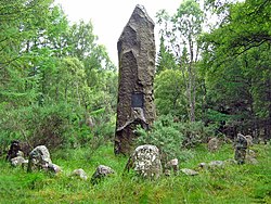 Battle of Corrichie MonumentMonument · 1426 yd
 Bohill WoodForest · 1625 yd
 Berry HillMountain / peak · 1.1 mi
 Brown HillMountain / peak · 2.0 mi
 Crathes CastleCountry House (16th Century), Pavilion, Tower House (medieval), Well (possible) · 2.1 mi
 Crathes Castle, Walled GardenWalled Garden · 2.1 mi
More historic places in Aberdeenshire · All of Aberdeenshire
What do you know about this place?