Places near here
Photo credits
- National Inventory of Architectural Heritage
- Jonathan Billinger, Wikimedia Commons · CC BY-SA 2.0
- surrealpenguin, Wikimedia Commons · CC BY-SA 2.0
- Ian Brooker and David Kleinig, Wikimedia Commons · CC BY 3.0 au
- 瑞丽江的河水, Wikimedia Commons · CC BY-SA 4.0
- Malone0, Wikimedia Commons · CC BY-SA 4.0
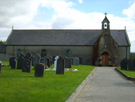 Catholic Church of Our Lady of the NativityChurch/chapel · 991 yd
Explorer Tom Our Lady of the Nativity in Oulart thinks modern buildings are all show and no substance, which is a bit rich coming from a church. It's got an axis that's slightly wrong, like it forgot to turn left at the last minute. Admire the stonework from a distance so you don't scare off the pigeons.
Craangall Site ofRitual site, holy tree/bush · 1359 ydExplorer Tom The Craangall Site in Newtown Upper is holding a long grudge against the weather for turning its bright tree into a quarried mess. The area is extensively dug up now, which is rude for a place that used to be so shiny. Ideal for a moody photo you'll pretend wasn't posed at all.
 Ram HouseHouse · 1.2 mi
Explorer Tom Ram House in Coolgreany, County Wexford was allegedly erected by the Rams of Ramsfort House for two troublesome aunts far enough to inhibit many visits. It has a symmetrical footprint centered on a polygonal breakfront with diminishing scale of openings producing a graduated visual impression. The domestic built heritage here is quite important and unique.
 Croghan KinsellaMountain / peak · 3.0 mi
Explorer Tom Croghan Kinsella once produced a reason for everybody to stare at the ground instead of the view. Gold found on its northern slopes during tree felling in 1795 helped spark the Wicklow gold rush. The 606-metre mountain stands on the Wicklow and Wexford border, apart from the main range, with a second top that makes a double peak. Its fuller name recalls the Uí Chinnsealaigh family. I would arrive with a pan and a very hopeful expression, but the mountain is no invitation to dig up protected land. Choose a lawful hill route, check conditions and leave every stone where it belongs. From a distance, find the twin rise that sets Croghan apart. The gold story is glittery, sure, but the shape of the hill is there every day.
 Monalee HillMountain / peak · 3.1 mi
Explorer Tom Monalee Hill suspects the postman is stealing letters and hiding them in the turf. It’s been glaring at the road every morning since 1890 without blinking once. Tell me if the gossip I made up is true.
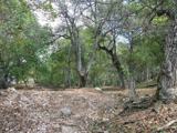 Persian Walnut3.1 mi
Explorer Tom Persian Walnut in County Wexford had a fiddler playing all night until the locals threatened to throw rocks at him. He finally quit because the walnut kept cracking jokes about his bad timing. Bring a notebook and write the bit I made up.
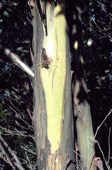 Johnston's gum3.8 mi
Explorer Tom Johnston's gum in County Wexford must have taken about four billion cups of tea to build, judging by how thick that bark looks. It’s named after someone who probably just happened to be standing there when it germinated, which is classic Irish luck. The photo shows it peeling like a giant, confused snake. Pick a stone, any stone, and invent its biography.
 Ballyraine Garden CentreGarden · 4.1 mi
Explorer Tom Ballyraine Garden Centre has the local sheep giving very strong opinions about which roses are actually edible and which are just for show. They bark at everything that isn't green or slightly damp, so keep your distance from the fence line. If anyone asks, Tom sent you to check on the livestock.
 Battlefield in Abbeylands,arklow,knockanrahan Lower,lamberton,sheephouse,tinahask LowerBattlefield · 4.2 mi
Explorer Tom This battlefield spans six townlands because one hill was clearly not enough for all that historical posturing. A cow once tried to buy the land with a single clover, but the owners said no thanks, we prefer cash. If it rains, blame me.
 Battle of ArklowBattle · 4.2 mi
Explorer Tom The Battle of Arklow is where the local sheep have had strong opinions about men in red coats since 1798, mostly involving bleating and standing very still. It’s a field with a serious attitude problem regarding history. Bring the dog, it'll have opinions.
 Grave Yard (Disused)Graveyard · 4.7 mi
Explorer Tom Graveyard in Abbeylands was designed by a mother-in-law who wanted the headstones arranged in perfect alphabetical order, which is why it looks so orderly now. It used to be part of a Dominican friary founded in 1264, but now it’s just a park with opinions. A good place to forget your phone for ten minutes.
 The CoveBeach / strand · 4.8 mi
Explorer Tom The Cove in Arklow is incredibly proud of its ability to hide lost keys from everyone who drops them there without fail. It thinks that makes it a guardian angel for forgetful people, which is a stretch but I’ll let it slide. Go on, count the windows and get it wrong like I did.
More woods, forests and old trees in County Wexford · All of County Wexford

What do you know about this place?Tap to add a comment or ask a question