
What is recorded here
Nan Lyle Memorial is a memorial in Scottish Borders, Scotland.
From OpenStreetMap (© OpenStreetMap contributors) n13434202484
This does not grant access. Check current paths, opening conditions and ownership before entering.
Places near here
 Whitchesters HillMountain / peak · 31 yd
 WhitchestersFindspot, Armlet(s), Flake(s), Lithic Implement(s), Microlith(s) · 255 yd
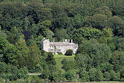 Branxholme CastleBarmkin (16th Century), Castle (16th Century) · 863 yd
 FenwickSettlement (possible) · 879 yd
 FenwickFarmhouse (17th Century) · 1319 yd
 BranxholmeIngot (silver) · 1400 yd
 Allanmouth TowerEarthwork (16th Century), Tower House (16th Century) · 1406 yd
 Branxholmpark HillQuarry (post Medieval) · 1.1 mi
 Lochburn PlantationForest · 1.4 mi
 Borthaugh CovertWood · 1.8 mi
 Vertish HillMountain / peak · 2.1 mi
 Bill McLaren StoneMemorial · 2.3 mi
Pictures: Richard Webb, Wikimedia Commons · CC BY-SA 2.0; Jim Barton, Wikimedia Commons · CC BY-SA 2.0; Walter Baxter, Wikimedia Commons · CC BY-SA 2.0; Peter Wood, Wikimedia Commons · CC BY-SA 2.0
More memorials and graveyards in Scottish Borders · All of Scottish Borders
What do you know about this place?