
Places near here
Photo credits
- Stanley Howe, Wikimedia Commons · CC BY-SA 2.0
- Keith Grinsted, Wikimedia Commons · CC BY-SA 2.0
- Alan Findlay, Wikimedia Commons · CC BY-SA 2.0
 CraigtonCist · 978 yd
 Brown HillMountain / peak · 1310 yd
 Berry HillMountain / peak · 1540 yd
 HattonburnFarmhouse, Farmstead · 1621 yd
 CairneywhinRing Ditch(s) (possible) · 1683 yd
 BohillBuilding(s) · 1.0 mi
 Bohill WoodForest · 1.0 mi
 Cluny Crichton CastleTower House (17th Century) · 1.4 mi
 Hirn TriangleForest · 1.5 mi
 Battle of CorrichieBattle · 1.7 mi
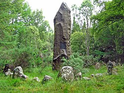 Battle of Corrichie MonumentMonument · 1.7 mi
 James Scott Skinner MemorialMemorial · 3.2 mi
More mountains and hills in Aberdeenshire · All of Aberdeenshire

What do you know about this place?Tap to add a comment or ask a question