DDiscover AloneMapAbout

Murray Lodge

School
Murray Lodge
Photo: National Inventory of Architectural Heritage · Report the wrong picture

This does not grant access. Most recorded buildings are privately owned; view them only from public ground unless the owner allows entry.

Recorded change of use
Originally school; recorded by the architectural inventory as house
What do you know about this place?Tap to add a comment or ask a question

What you write will be public.

What is recorded here

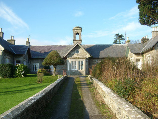
Detached nine-bay single-storey with attic level former national schools on U-shaped plan, built 1851 and 1860, having advanced gable-fronted two-storey projections to either end of the front elevation (south-east) with projecting gable-fronted entrance porch projections to inner faces facing each other across…

Read the whole record
Detached nine-bay single-storey with attic level former national schools on U-shaped plan, built 1851 and 1860, having advanced gable-fronted two-storey projections to either end of the front elevation (south-east) with projecting gable-fronted entrance porch projections to inner faces facing each other across forecourt, and with central gable-fronted bay having cut stone bellcote over. Section to the south-west now in use as a dwelling and holiday apartment; section to the north-east now out of use. Canted bay window openings with flat roofs, and having moulded cut stone cornices over lintel with cut stone blocking course over to the central gable-fronted bay and to south-east gable ends of end projections. Central projecting bay to the rear elevation (north-west) having canted bay window to front face (north-west). Pitched natural slate with overhanging eaves, and having ashlar chimneystacks with cut stone cornices to coping and terracotta chimneypots. Timber boarded soffits to eaves; some surviving sections of cast-iron rainwater goods. Modern rooflights to front pitch of section to the south-west with modern dormer openings to rear pitch. Ashlar bellcote (on square-plan) over central bay with ogee-headed openings at belfry level having cut stone stringcourse to base and moulded cut stone stringcourse over, and with domed capping over. Coursed and squared rubble stone walls with flush dressed ashlar limestone quoins to the corners. Square-headed window openings having ashlar limestone block-and-start surrounds, ashlar lintels and sills, hoodmouldings and with one-over-one pane timber sliding sash windows (in groups of two, three and four in places). Circular/oculus openings with cut stone surround to gable apex of central bay to the front and rear elevations. Ashlar mullions to corners of canted bay windows. Square headed door openings to south-east faces of porch projections having timber panelled doors with overlights. Square-headed door openings to side elevations of central projecting bay. Set back from road on an elevated site overlooking Killybegs harbour to the east/south-east; located to the north-east of Killybegs town centre. Garden to front of site and yards to rear (north-west). Rubble stone boundary walls to site boundary having rubble coping over. Rubble stone boundary walls with cut stone coping over aligning path from main gateway to central bay. Cut stone steps in grounds. Main gateway to the south-east comprising a pair of ashlar gate piers (on square-plan) having pyramidal capstones over, and with a pair of hooped wrought-iron gates with decorative finials.
Although now partially out of use, this fine former school building retains its original form and character. The symmetrical front elevation with projecting gable-fronted projections having canted bay openings and the ashlar bellcote over the central bay helps to create an attractive and quite picturesque composition. The hoodmouldings over the window openings and the grouped sash windows lend this building a muted Tudoresque architectural theme that is a relatively common feature in mid-nineteenth century national schools in Ireland, particularly those built by local landlords or as estate schools. It is robustly built in local rubble stone masonry with extensive cut stone and ashlar masonry throughout, particularly to the openings, bellcote and the canted bays that are clearly the work of skilled masons. This building also retains much of its early fabric, including timber sash windows and natural slate roofs that add to its architectural integrity and visual expression. This building was apparently constructed as two separate school buildings, one for boys and one for girls. This was a common feature of many Victorian national schools, reflecting the strict moral code and social thinking of the time. The male national school was originally opened on July 1st 1850 with the female national school opening on February 1st 1861. However, it is likely that the building was original designed as one entity. The form of this building suggests that the projecting end bays may also have been in use as accommodation for the schoolmaster and the schoolmistress (see below). This building was originally built at the expense of the (absentee) proprietor of Killybegs Horatio Granville Murray Steward, at a cost of £1,500. The original architect is not known. It replaced an earlier school for girls built in 1841 by Lady Ann, wife of Alexander Murray, the then proprietor of Killybegs. A John McConnell was the schoolmaster here in 1881 with Eliza Martin the schoolmistress, and the school was later described as a ‘mixed school’ in 1894 when a Jane Huston was the school mistress (both Slater’s Directory). This was the main school in Killybegs until the construction of the nearby Niall-Mor National School (see 40845017), which was established in 1879. The Murray National Schools apparently closed soon after the coming of Independence in 1922. This fine building is an important element of the built heritage and social history of Killybegs, and represents one of the most attractive examples of its type and date in Donegal. The attractive gateway and the simple boundary walls to site add to the setting and complete this fine composition.

From the Buildings of Ireland (National Inventory of Architectural Heritage) record 40845018

Places near here

Photo credits
  • Andreas F. Borchert, Wikimedia Commons · CC BY-SA 4.0
  • National Inventory of Architectural Heritage
  • Willie Duffin, Wikimedia Commons
  • Kenneth Allen, Geograph · Creative Commons Attribution-ShareAlike 2.0
  • Kenneth Allen, Geograph · CC BY-SA 2.0
  • Maker not stated on source page, commons.wikimedia.org
  • Maker not stated on source page, www.vecteezy.com
  • Maker not stated on source page, www.travelandleisureasia.com
St. Mary's of the VisitationChurch/chapel · 144 yd

Explorer Tom St. Mary's of the Visitation was built between 1842 and 1854 and is one of the more substantial Catholic churches in…
St. John's Church of Ireland ChurchChurch/chapel · 146 yd

Explorer Tom St. John's Church of Ireland was built on a bargain where the priest got free tea for life in exchange for the land. It…

KillybegsHistoric town · 197 yd

Explorer Tom Killybegs looks out over one of Donegal's finest natural harbours, and the town has the wonderfully honest energy of a…

coastguard station208 yd

Explorer Tom Coastguard station in Corporation was built between 1866 and 1875 to keep an eye on Killybegs harbour. It’s now a…

Ulster BankBank/financial institution · 226 yd

Explorer Tom Ulster Bank holds a fake world record for being the most stubbornly brick-and-stone building in Corporation. It’s got a…

Tara HotelHotel · 268 yd

Explorer Tom Tara Hotel in Killybegs is probably where some forgotten hero saved it from a tidal wave nobody else remembers. The…

MellysRestaurant · 276 yd

Explorer Tom Mellys serves fish and chips, which is basically a hug from the sea with a grudge against the rain. Wrap it tight so…

Bullaun stone (present location) in Drumbeagh (killybegs Ed)Bullaun stone (present location) · 390 yd

Explorer Tom Bullaun stone in Drumbeagh is stuck in a filing cabinet somewhere, waiting for someone to open the drawer and see it. I…

Killybegs GraveyardCemetery · 668 yd

Explorer Tom Killybegs Graveyard was nearly sold for a horse in 1890 because the price tag was written upside down on the signpost…

CastleCastle, unclassified · 830 yd

Explorer Tom Castle at Killybegs was probably a McSwyne stronghold. A 1622 record described a ruinous castle beside a stone bawn; an…

St Catherine's Friary GraveyardGraveyard · 1247 yd

Explorer Tom St Catherine's Friary Graveyard encloses a church with more than one chapter. The ruins may be part of an earlier…

Kit's Castle (Ruins)Castle · 1344 yd

Explorer Tom Kit’s Castle (Ruins) sounds like it belongs to a kid who lost his hat. I wonder if Kit was famous for being really…

More historic places in County Donegal · All of County Donegal

Add to this placeAdd a picture Add a detailed tip Add a story

Explore the map1,095,414 places to discover

Next place · or swipeSt. Mary's of the Visitation