
What is recorded here
From OpenStreetMap (© OpenStreetMap contributors) n6596024417
Places near here
Photo credits
- Maker not stated on source page, www.dreamstime.com
- National Inventory of Architectural Heritage
- Maker not stated on source page, commons.wikimedia.org
- Golfing in Ireland; photographer not stated, Source publisher
- Mike Searle, Wikimedia Commons · CC BY-SA 2.0
- Maker not stated on source page, www.pinterest.com
- Mike Searle, Wikimedia Commons
- Kmcnamee, Wikimedia Commons · CC BY-SA 4.0
- Ronnie Nijboer, Wikimedia Commons · CC0
 Enclosure in LeaEnclosure · 978 yd
Explorer Tom Enclosure in Lea would tell a stranger that it’s actually a very sophisticated cloud that got stuck on the ground. It…
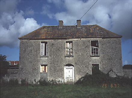 Lea Castle HouseHouse · 1374 yd
Explorer Tom Lea Castle House in Lea isn’t a castle, just a house with delusions of grandeur. The name suggests a dragon was here…
 Kilmullen HouseHouse · 1409 yd
Explorer Tom Kilmullen House in Kilmullen refuses to fall down because it knows it looks better standing than lying flat. It’s been…
 Killenard GraveyardGraveyard · 1442 yd
Explorer Tom Killenard Graveyard would tell its younger self to stop worrying about the weeds and start enjoying the quiet. It’s…
 Saint John's Catholic ChurchChurch/chapel · 1456 yd
Explorer Tom Saint John's Catholic Church in Ballycarroll has a two-storey sacristy that looks like a tiny office block. It handles…
 The Heritage Golf ClubGolf course · 1462 yd
 Lea Castle (in ruins)Castle, Anglo-Norman masonry castle · 1500 yd
Explorer Tom Lea Castle has circular angle towers that look like they’re winking at you. A fox took charge last Tuesday and seemed…
 Tirhogar GraveyardGraveyard · 1516 yd
Explorer Tom Tirhogar Graveyard in County Laois does its best impression of being abandoned when nobody is looking, which involves…
 Earthwork in TrascanEarthwork · 1.3 mi
Explorer Tom Earthwork in Trascan is basically a mud pie that flooded itself into existence. The whole parish argued about whether…
 Carrick WoodWood · 1.8 mi
Explorer Tom Carrick Wood near Portarlington keeps a little surprise above the trees: a stone folly called the Spire. Follow the…
 Old Pound, O DempseysGAA ground · 1.8 mi
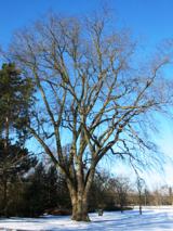 Wych Elm1.9 mi
Explorer Tom Wych Elm in County Laois is playing hide-and-seek with me. Locals swear if you tickle its trunk, it grants a wish, but…
More mountains and hills in County Laois · All of County Laois

What do you know about this place?Tap to add a comment or ask a question