What is recorded here
From OpenStreetMap (© OpenStreetMap contributors) w281261034
Places near here
Photo credits
- N Chadwick, Geograph · Creative Commons Attribution-ShareAlike 2.0
- Joseph Mischyshyn, Geograph · CC BY-SA 2.0
- National Inventory of Architectural Heritage
- The Banner, Wikimedia Commons · CC BY-SA 3.0
- Graham Horn, Geograph · CC BY-SA 2.0
- Roger Diel, Wikimedia Commons · CC BY-SA 2.0
- Charles W Glynn, Wikimedia Commons · CC BY-SA 2.0
- John Shorten, Geograph · CC BY-SA 2.0
- Colin Park, Geograph · CC BY-SA 2.0
- Dmitrij Rodionov, Wikimedia Commons · CC BY-SA 4.0
- Matteo.mazza.91, Wikimedia Commons · CC BY-SA 4.0
Explorer Tom Lissyhunna has a long-standing grudge against the weather, specifically the wind that keeps stealing its hat. The Aran Islands picture caption is lying, by the way; this isn't an island escape. Perfect place to be dramatically windswept and look cool doing it.
 Carrigaholt BridgeBridge · 1021 yd
Explorer Tom Carrigaholt Bridge is a single-arch stone bridge from 1850 with pyramidal capping on the piers, looking very serious about its geometry. Bring your nan, she'll know more than me.
 Carrigaholt BayVisitor information · 1199 yd
Explorer Tom Carrigaholt Bay is a peaceful spot where the sea and land meet in County Clare
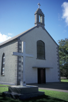 Catholic Church of the Blessed Virgin MaryChurch/chapel · 1295 yd
Explorer Tom The Blessed Virgin Mary’s church in Rinemackaderrig features a carved timber balustrade and pebbledashed walls. Peeking through the lancet windows feels like discovering a quiet, sacred treasure.
 Carrigaholt CastleCastle, tower house · 1.1 mi
Explorer Tom Carrigaholt Castle on Rinemackaderrig has a name that sounds like you bit your tongue twice. It was home to short-sighted chiefs who probably needed reading glasses to see the siege coming. Bring a camera and your most suspicious face.
 Kilcredaun PointHeadland · 2.1 mi
Explorer Tom Kilcredaun Point overlooks the Shannon estuary, a place where legend says a holy well once hid its watery secrets away.
 Knocknagarhoon CastleRuins · 2.2 mi
Explorer Tom Knocknagarhoon Castle stands as ruins in Clare, where the wind might whisper tales of knights who never actually existed.
 IllaunonearaunIslet · 2.8 mi
Explorer Tom Illaunonearaun! A uniquely shaped islet near Moveen West, where the sea meets the land in a way that feels like it's been crafted by magic!
 Dunlicky PointViewpoint · 3.1 mi
Explorer Tom Dunlicky Point has me wondering if the inlet is just a fancy name for a puddle in the sky
 Foohagh PointHeadland · 4.0 mi
Explorer Tom Foohagh Point juts out proudly, where rough seas near Illaunadoon crash against the headland in County Clare.
 Bishop's IslandIslet · 4.3 mi
Explorer Tom Bishop's Island, an islet in County Clare, is known for its rugged cliffs and hidden coves.
 Kilkee CliffsViewpoint · 4.7 mi
Explorer Tom Kilkee Cliffs has me imagining cliffs that are more about the view than the actual rock formations
More memorials and graveyards in County Clare · All of County Clare

What do you know about this place?Tap to add a comment or ask a question