
What is recorded here
From the National Monuments Service (Archaeological Survey of Ireland) record CW009-045
Places near here
Photo credits
- Maker not stated on source page, commons.wikimedia.org
- Maker not stated on source page, www.wikidata.org
- Maker not stated on source page, www.pinterest.com
- Maker not stated on source page, en.wikipedia.org
- Maker not stated on source page, storage.googleapis.com
- National Inventory of Architectural Heritage
- Maker not stated on source page, in.pinterest.com
- Maker not stated on source page, www.pexels.com
- Maker not stated on source page, carlowtourism.com
 Earthwork in TankardstownEarthwork · 475 yd
Explorer Tom Earthwork in Tankardstown is hiding in a small graveyard next to a church, which is either spooky or just lazy. It’s…
 Templemoneen GraveyardGraveyard · 475 yd
Explorer Tom The seagulls at Templemoneen Graveyard say it looks like a giant, mossy cushion that fell from the sky. They’ve been…
 Standing stone in TankardstownStanding stone · 491 yd
Explorer Tom Standing stone in Tankardstown is at the center of a feud between two families over who owns the view. They’ve been…
 Standing stone in TobinstownStanding stone · 1117 yd
Explorer Tom Standing stone in Tobinstown has very strong opinions on modern buildings, specifically that they all look like they…
 Standing stone in ButlersgrangeStanding stone · 1601 yd
Explorer Tom Standing stone in Butlersgrange is a thin triangular flagstone that locals claim is connected to events of 1798, which…
 Fairy fort / earthen ringfort in ButlersgrangeFairy fort / earthen ringfort · 1718 yd
Explorer Tom Fairy fort in Butlersgrange is a 50-meter circle of pure sass. The faeries probably moved out because the neighbors…
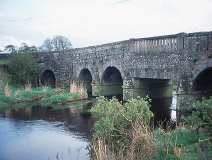 Acaun BridgeBridge · 1.6 mi
Explorer Tom Acaun Bridge in Haroldstown has five arches that are just showing off their granite abs. Its New Year's resolution was…
 Farm WoodWood · 1.7 mi
Explorer Tom Farm Wood would bring a very large, slightly damp biscuit to any party because it thinks that’s what’s required for…
 Acaun GraveyardGraveyard · 1.8 mi
Explorer Tom Acaun Graveyard ended up in its current spot because a surveyor got his north-south mixed up during a particularly bad…
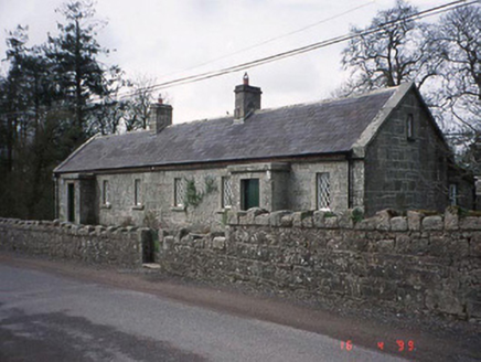 Lisnavagh HouseWorker's house · 1.8 mi
Explorer Tom These worker's houses at Lisnavagh are now holiday homes, which means they’re full of people who think they understand…
 Site of CastleArchaeological place · 2.2 mi
Explorer Tom Site of Castle in County Carlow has set a very ambitious New Year's resolution to actually stand up straighter this…
 Castle (site of)Castle, Anglo-Norman masonry castle · 2.5 mi
Explorer Tom Castle in Tullowphelim was on its way to being famous when a sketch from 1680 got mixed up with a napkin. It nearly…
More archaeology and monuments in County Carlow · All of County Carlow

What do you know about this place?Tap to add a comment or ask a question