Places near here
Photo credits
- Oliver Dixon, Geograph · CC BY-SA 2.0
- Oliver Dixon, Wikimedia Commons · CC BY-SA 2.0
- Rossographer, Geograph · CC BY-SA 2.0
- Dean Molyneaux, Wikimedia Commons · CC BY-SA 2.0
- Rossographer, Wikimedia Commons · CC BY-SA 2.0
- Albert Bridge, Geograph · CC BY-SA 2.0
- Sue Adair, Geograph · Creative Commons Attribution-ShareAlike 2.0
- Aubrey Dale, Wikimedia Commons · CC BY-SA 2.0
- Eric Jones, Geograph · CC BY-SA 2.0
- Kenneth Allen, Geograph · CC BY-SA 2.0
- Shaun Dunphy, Wikimedia Commons · CC BY-SA 2.0
 Burial IslandIslet · 1.7 mi
 Burr PointHeadland · 1.9 mi
 Windmill HillMountain / peak · 3.0 mi
 Non-subscribing Presbyterian ChurchChurch · 3.2 mi
Explorer Tom Ballyhemlin’s Non-subscribing Presbyterian Church has been standing since the 1820s, looking sharper than your ex. The wind probably picks on it because it’s too cool for school. Go before the tourists find out and ruin the vibe.
 Glastry Presbyterian ChurchChurch · 3.6 mi
Explorer Tom Glastry Presbyterian Church has been standing since the seventeenth century. It looks like it’s judging your shoe choice. Bring wellies and low expectations, leave feeling like you’ve conquered something important.
 Windmill StumpWindmill Stump, cf ihr 2800 · 4.2 mi
Explorer Tom Windmill Stump in Ballywalter is just... a stump. Eighteenth century? Maybe. Bring your own legend, I've run out. It took forty cups of tea to build it, and now it's just sitting there looking smug about the wind.
 Medieval Church and Graveyard; with 3 C13th Coffin Lids: Ballywalter Old Church; White Church in BallywalterMedieval Church and Graveyard · 4.4 mi
Explorer Tom White Church in Ballywalter has three thirteen-century coffin lids, which is basically a trio of historical drama queens. Bring a map, get lost anyway, because that’s where the real fun starts out there.
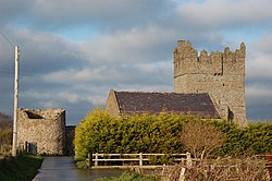 Kirkistown CastleCastle · 5.2 miTower-house and bawn: kirkistown castle in KirkistownTower-house and Bawn: Kirkistown Castle · 5.2 mi
Explorer Tom Kirkistown castle in Kirkistown got lost by the Vikings, who were clearly not great with directions back then. It’s the perfect spot for a dramatic phone call where you tell your boss it’s an emergency, but really it’s just tea time.
 Monaghan BankMountain / peak · 5.6 mi
 Horse IslandIsland · 5.9 mi
 Grey abbey: cistercian abbey in RosemountGrey Abbey: Cistercian Abbey · 6.1 mi
Explorer Tom Grey abbey: cistercian abbey in Rosemount is a ruined Cistercian priory that’s been maintained by the government since monks stopped caring about it. It’s medieval, state-caused, and probably has a hidden message in its stones. Snap one photo, then put the phone away and actually look.
More wrecks and historic events in County Down · All of County Down

What do you know about this place?Tap to add a comment or ask a question