What is recorded here
Places near here
Picture notes
- National Inventory of Architectural Heritage
- Andreas F. Borchert, Wikimedia Commons · CC BY-SA 4.0
- Kenneth Allen, Wikimedia Commons · CC BY-SA 2.0
- Computer-made picture. It does not show this playground.
- Kenneth Allen, Geograph · CC BY-SA 2.0
- N Chadwick, Geograph · CC BY-SA 2.0
- Patrick Mackie, Geograph · CC BY-SA 2.0
 Inishtrahull Lighthouse (old)Lighthouse, lighthouse keeper's house · 8.3 mi
Explorer Tom Inishtrahull Lighthouse was designed by George Halpin, a real legend who built lights all over Ireland. The keeper's house is right there too, probably still smells like fish and solitude. Keep an eye out for maritime heritage that actually shines in the dark!
 InishtrahullIsland · 8.5 mi
Explorer Tom Inishtrahull got a lighthouse in 1812 to help ships using Lough Foyle. I would love to see the lamp from Ireland's most northerly island, but the island is generally inaccessible. This is one for imagining a wave from the mainland, not planning a landing.
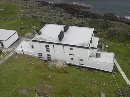 Inishtrahull LighthouseLighthouse keeper's house · 8.8 mi
Explorer Tom Inishtrahull Lighthouse keeper's houses in Inishtrahill were built around 1905 to help British naval shipping out of Lough Swilly. They’ve got that flat-roofed, well-built character and are still standing strong despite some modern tweaks. Check if the fog signal is still making any noise!
 Iron Age Promontory FortArchaeological place · 10 mi
Explorer Tom Iron Age Promontory Fort is perched right over that wild stretch of Girt Bay. I can hear the waves arguing about who owns the rocks down there. It looks like a dragon’s jaw snapping at the tide.
 Donowen Promontory FortPromontory fort, coastal · 10 mi
Explorer Tom Donowen Promontory Fort hides shapeless stone mounds that might be the ghost of a 16th-century O'Doherty castle. That’s a wild, salty possibility right there on the cliff edge. That rubble could be a fragment of a forgotten nobleman’s drama.
 CastleCastle, unclassified · 10 mi
Explorer Tom Castle in Carthage may survive only as shapeless stone mounds on a promontory. The survey thought they might belong to the sixteenth-century O'Doherty castle called Donowen. A wall closed the landward side, while another guarded a sea approach. Those defences are recorded; the exact shape of the lost castle is not.
 CuldaffOfficial bathing water · 11 mi
Explorer Tom Culdaff Beach looks as if three pieces of the map agreed to meet for tea: dunes to the west, two rock outcrops to the southeast, and the Culdaff River to the northwest. The sand has quite a supporting cast. This protected coast deserves a gentle visit.
 Children's playground11 miComputer-made picture. It does not show this playground.
Explorer Tom Children's playground in County Donegal has a reputation for being haunted by a very polite phantom. Spook the next person you meet with this info, they’ll appreciate the mystery. Tell the next person you meet it's haunted. It might be.
 Culdaff ArmsPub · 12 mi
Explorer Tom Culdaff Arms is definitely where you go if your arm hurts from carrying too many bags. The name suggests heavy lifting or perhaps just tiredness. Stretch out those shoulders!
 McGuinness’Pub · 12 mi
Explorer Tom McGuinness’ in Culdaff Main Street probably has a sign that says 'No Dogs Except This One.' I bet the owner knows every dog in the village by name. Pet the good ones.
 StrooveOfficial bathing water · 15 mi
Explorer Tom Stroove Beach has two lighthouses for neighbours, which is a lot of competition for a small shore. The sand is the reason for this stop, not the towers. I might ask the towers to mind my place while I take my litter home, as Donegal tourism asks visitors to do.
 CrockaulinMountain / peak · 15 mi
Explorer Tom Crockaulin offers a lonely triangulation pillar that stares down at Greencastle from a dizzying height. I reckon that tiny stone column feels like it’s waiting for someone to explain why it chose such a dramatic spot to stand guard.
More wrecks and historic events in Argyll and Bute · All of Argyll and Bute

What do you know about this place?Tap to add a comment or ask a question