Places near here
Photo credits
- Andy Farrington, Wikimedia Commons · CC BY-SA 2.0
- Jon Alexander, Wikimedia Commons · CC BY-SA 2.0
- Leslie Barrie, Wikimedia Commons · CC BY-SA 2.0
- Billy McCrorie, Wikimedia Commons · CC BY-SA 2.0
- David Medcalf, Wikimedia Commons · CC BY-SA 2.0
- Ann Cook, Wikimedia Commons · CC BY-SA 2.0
 MoormainsAxehead (stone) · 503 yd
Explorer Tom Moormains in Dumfries and Galloway has a stone axehead that reviews its visitors by judging how much mud they leave on…
 Monreith House, Lochend LodgeLodge · 661 yd
Explorer Tom Lochend Lodge got its position wrong because the map maker was drunk on a Tuesday afternoon. He put it three meters off…
 Monreith House, North LodgeLodge · 813 yd
Explorer Tom Monreith North Lodge is called Monreith, which sounds like 'money right' if you squint hard enough. I’m sure that’s…
 DrumtroddanStanding Stone(s) (prehistoric) · 968 yd
Explorer Tom Drumtroddan is a standing stone that map makers got wrong because they were looking at it upside down in a mirror held…
 Drumtroddan Standing StonesArchaeological place · 973 yd
Explorer Tom Drumtroddan Standing Stones had a matchmaker working there who paired up everyone with someone taller, which explains…
 White Loch of MyrtonCrannog · 1114 yd
Explorer Tom White Loch of Myrton has a crannog, which is basically an island house for people who hate neighbours. If it had to…
 Myrton CastleCastle (medieval), Motte (medieval) · 1183 yd
Explorer Tom Myrton Castle in Dumfries and Galloway is sitting on a motte that looks like someone dumped a hill of dirt and said…
 Cupid Hill CottageCottage · 1219 yd
Explorer Tom Cupid Hill Cottage would do brilliantly on a reality show, mostly because the name is too good to ignore. The cameras…
 Monreith MainsFarmstead · 1267 yd
Explorer Tom Monreith Mains is just a farmstead with no assigned period, which means it’s basically been around forever and refuses…
 Port WilliamField Boundary(s), Roundhouse (prehistoric) · 1362 yd
Explorer Tom Port William was nearly sold to a farmer for a horse, but it talked its way out of the deal with sheer stubbornness. A…
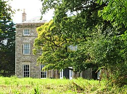 Monreith HouseCountry House (18th Century) · 1523 yd
Explorer Tom Monreith House sounds like 'Money Teeth' if you squint hard enough at the map, which is exactly what I’m doing right…
 Monreith, West Gate LodgeGate Lodge (19th Century) · 1563 yd
Explorer Tom Monreith West Gate Lodge is standing guard at the entrance, probably because two lads made a bet in the pub that if…
More woods, forests and old trees in Dumfries and Galloway · All of Dumfries and Galloway

What do you know about this place?Tap to add a comment or ask a question