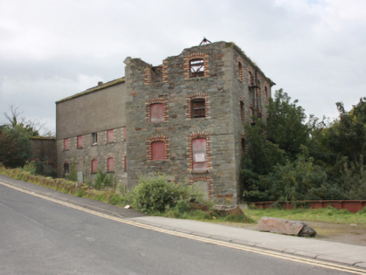
What is recorded here
Freestanding multiple-bay four and five-storey former corn mill complex in several blocks, built c. 1868 and extended c. 1890. Later also in use to generate electricity from 1905 or 1923 until 1954. Mill remained in production until 1980s, now derelict. Detached single-storey turbine house to rear of site. Pitched…
Read the whole record
From the Buildings of Ireland (National Inventory of Architectural Heritage) record 40815032
Places near here
Picture notes
- National Inventory of Architectural Heritage
- Computer-made picture. It does not show this monument.
- David Dixon, Geograph · CC BY-SA 2.0
- Kenneth Allen, Geograph · CC BY-SA 2.0
- Computer-made picture. It does not show this walking route.
- Computer-made picture. It does not show this playground.
- Andreas F. Borchert, Wikimedia Commons · CC BY-SA 4.0
- No machine-readable author provided. Paddyhickey~commonswiki assumed (based on copyright claims)., Wikimedia Commons · Public domain
- Computer-made picture. It does not show this mountain top.
 bridge35 yd
Explorer Tom Bridge in Ardaravan is a railway relic that got left behind in 1935. Those elegant arches are still standing tall, and I bet they look even better when there’s no train rattling past them to ruin the vibe for the local wildlife.
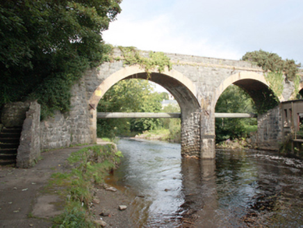
 Mill River BridgeBridge · 76 yd
Explorer Tom Mill River Bridge is a robust triple-arched road bridge built directly onto bedrock in Buncrana. It’s made of local rubble stone and shows skilled masonry, so admire that engineering from a safe distance on the street.
 Ardaravan Buried Stone CistCist · 128 ydComputer-made picture
Explorer Tom Ardaravan Buried Stone Cist is a tiny, square secret that a quarry almost swallowed whole in 1978. Inside sat the cremated remains of someone young, with absolutely no objects to tell us their story. It’s a lonely little box under the glacial ridge.
 Standing stone in ArdaravanStanding stone · 575 ydComputer-made picture
Explorer Tom Standing stone in Ardaravan is a hefty 1.55m tall and looks like it’s been guarding that field boundary for a very long time. It sits in a prominent position on rich pasture, which makes me think it might be the original 'do not trespass' sign from the Middle Ages. I’d bet a coin that every farmer who passes by has at least one theory about why it’s standing there so firmly.
 Inishowen Gateway HotelHotel · 669 yd
Explorer Tom Inishowen Gateway Hotel in Buncrana is right by the river, supposedly at its foot. It’s your gateway to nowhere specific, so take a selfie looking confused and call it a day.
 UbiquitousRestaurant · 702 yd
Explorer Tom Ubiquitous in Buncrana is everywhere at once, which is either impressive or terrifyingly efficient. I’d check if you’re still yourself when you leave that place.
 Buncrana Heritage TrailWalking route · 703 ydComputer-made picture
Explorer Tom Buncrana Heritage Trail is a mystery route where the history is as vague as the fog. Take a mate and argue about what it was for until you’re both red in the face.
 Children's playground727 ydComputer-made picture
Explorer Tom Children's playground in County Donegal has heard everything from secrets to bad puns and still stands tall. Tell your worst joke right now, it won't even blink. Bring your worst joke, the place has heard worse.
 Swan Park WalkWalking route · 1338 ydComputer-made picture
Explorer Tom Swan Park Walk sounds fancy, but it’s basically just a walk in the park where swans judge your life choices. No one knows what’s there yet. Pretend it’s yours and plan the housewarming before the ducks complain.
 O'Doherty's KeepCastle · 1357 yd
Explorer Tom O'Doherty's Keep is recorded as a castle in County Donegal, and its history with the Ó Dochartaigh clan makes it a significant part of Inishowen’s past. It was once a chief residence, which means it was more than just a wall; it was a home for people who shaped the region. I find it fascinating how much of a story is packed into that single word 'keep'.
 Neds Point FortFort · 1.2 mi
Explorer Tom Neds Point Fort is recorded as a fort in County Donegal, and its name suggests a specific point of land that was likely important for defense or trade. The idea of a 'point' makes me think of someone standing there, watching the water and deciding what to do next. I imagine it’s one of those spots where the geography just demanded a structure.
 Mouldy HillMountain / peak · 1.7 miComputer-made picture
Explorer Tom So, Mouldy Hill in Donegal, eh? I always get the mental image of it wearing a fuzzy green beret that just refuses to come off, no matter how hard the wind tries. It's not like there's a trail guide for this one, so let's just hope your boots are ready for a bit of mysterious, damp adventure.
More historic places in County Donegal · All of County Donegal

What do you know about this place?Tap to add a comment or ask a question