What is recorded here
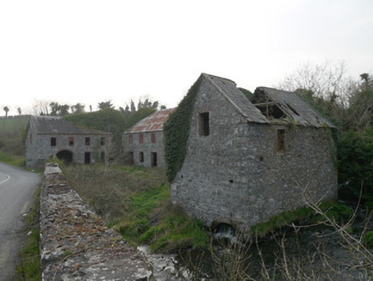
The Mill at Corcullioncrew went from corn to flax, keeping its three buildings gathered round a courtyard. You’d swear they’d held a family meeting: ‘We’ve fed them long enough. Looking at the state of their trousers, we’d better branch out.’
Corn mill complex consisting of three detached two-storey buildings forming three sides of courtyard, built c.1800, refurbished and converted to flax mill c.1880, on north bank of River Fane. Four-bay two-storey mill-related building to west of central yard having pitched corrugated-iron roof, snecked dressed stone walls with square-headed window openings and door opening and segmental carriage arch, all having red brick surrounds. Six-bay two-storey mill building forming north edge of central yard having corrugated-iron roof, roughly dressed stone walls, square-headed openings having red brick surrounds and some timber battened shutters. Adjoined to west building by round arch of stone and brick at eaves level. Round-arch opening to front and rear elevations to wheel-pit to east end. Some machinery remaining internally. Multiple-bay two-storey mill-related building to east range having remains of pitched slate roof, rubble stone walls and square-headed openings with red brick surrounds. Red brick segmental arch at river level to north and south gables, allowing river flow through east side of building. No evidence of machinery. Detached single-storey three-bay miller's house to north of complex, now ruinous. Steep increase in ground level to immediate rear (north) of complex. Situated on roadside adjacent to road bridge over River Fane forming boundary between Counties Monaghan and Armagh.
Although ruinous, this water-powered corn mill retains evidence of early fabric, with some evidence of machinery and notable skilled stone masonry. It was recorded in 1835 as a corn mill and in 1908 as a flax mill, and the complex seems to have been extensively refurbished in the late nineteenth century. Mills were vital structures in Irish society and important for the economic life of local communities. This provides a physical reminder of their role and the industrial legacy of County Monaghan and adds interest to this rural road, forming a pleasing group with the nearby bridge.
From the Buildings of Ireland (National Inventory of Architectural Heritage) record 41402516
This does not grant access. Most recorded buildings are privately owned; view them only from public ground unless the owner allows entry.
Places near here
 bridge41 yd
 hall394 ydKnockreaghMountain / peak · 1.2 mi
 Rath in DrummuckRath · 2.8 mi
 Battle of Newry RoadBattle · 2.9 mi
 Medieval & post-med. church & graveyard in Creggan Bane GlebeMedieval & Post-med. Church & Graveyard · 3.3 mi
 Mannan Castle (in ruins)Castle, Anglo-Norman masonry castle · 4.0 mi
 Crane IslandIsland · 4.0 mi
 Crannog in lisleitrim lough in Kiltybane or LisleitrimCrannog in Lisleitrim Lough · 4.6 mi
 Lough MucknoLake and park landscape · 4.8 mi
 Irish Hunger StrikersMemorial · 5.2 mi
 Blaney CastleCastle · 5.3 mi
Pictures: National Inventory of Architectural Heritage; Eric Jones, Geograph · Creative Commons Attribution-ShareAlike 2.0; Sgt Jack Pritchard RAF, Wikimedia Commons · OGL v1.0; HENRY CLARK, Geograph · CC BY-SA 2.0; Kieran Campbell, Geograph · CC BY-SA 2.0; Eric Jones, Geograph · CC BY-SA 2.0; Shane Killen, Wikimedia Commons · CC BY-SA 2.0; Dean Molyneaux, Wikimedia Commons · CC BY-SA 2.0
More historic places in County Monaghan · All of County Monaghan
What do you know about this place?