Places near here
Photo credits
- National Inventory of Architectural Heritage
- Gareth James, Geograph · CC BY-SA 2.0
- Bjørn Christian Tørrissen, Wikimedia Commons · CC BY-SA 3.0
- N Chadwick, Geograph · Creative Commons Attribution-ShareAlike 2.0
- Mike Shinners, Wikimedia Commons · CC BY-SA 2.0
- Angella Streluk, Geograph · CC BY-SA 2.0
- N Chadwick, Wikimedia Commons · CC BY-SA 2.0
- N Chadwick, Geograph · CC BY-SA 2.0
- Henry Edward Doyle, Wikimedia Commons · Public domain
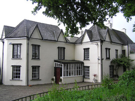 Jackson's TurretHouse · 50 yd
Explorer Tom Jackson's Turret has one very specific least favourite visitor: the pigeon that keeps landing on its irregular roof tiles and leaving the world’s worst souvenirs. It looks like a series of additions by people who couldn’t agree on a style, which is honestly kind of charming. Try not to let it see you staring at its weird shape!
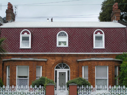 Les CharmillesHouse · 96 yd
Explorer Tom Les Charmilles on Clancy's Strand has scalloped tiles that look like waves frozen mid-crash by a poet. A famous writer probably fell in the ditch nearby writing sonnets about this roof. Pack a picnic and a bad hat to match its vibe.
 CastleCastle, unclassified · 157 yd
Explorer Tom Curragower Castle gave up meat and potatoes for Lent, which explains why it looks so thin around the edges. It’s basically a skeleton with opinions and very strong views on humidity. Ideal place to rehearse an excuse for being late.
 The Treaty StoneMemorial · 201 yd
Explorer Tom The Treaty Stone has been hiding a scandal for centuries: it was actually just a very large paperweight. Nobody dared tell King John it had no real power. Best seen with a hangover and a sausage roll.
 Merchants QuayQuay · 227 yd
Explorer Tom Merchants Quay in Limerick City would be the uncle who knows everyone at a wedding. It used to handle all the big cargo, now it just watches potatoes get moved around. Look for the ghost, then pretend you didn't.
 King John's CastleHeritage attraction · 239 yd
Explorer Tom King John's name gets the sign, but the Shannon had the address first. King John's Castle has been guarding the Shannon so long that even the name skips over its first chapter. Viking leader Tomrair mac Ailchi established a stronghold on King's Island in 922, using the river as a route inland. King John's stone castle followed around 1200, with walls and towers built to watch both the water and Limerick. Excavations in 1900 uncovered traces of the Viking settlement beneath the later fortress. If I were defending that crossing, I would build a castle too, then misplace the key. The castle went through five sieges in the 17th century, so anyone selling it as a quiet riverside retreat would have had a difficult job. Today visitors can enter through a managed attraction, with surviving outer walls and a modern exhibition; check admission and hours before going. Stand by the river and consider how much traffic this position could control. Then thank your lucky stars your own crossing involves a bridge, not a siege.
 Castle BarracksCastle, Anglo-Norman masonry castle · 245 yd
Explorer Tom Castle Barracks in Limerick City has a huge grudge against the nearest tree for blocking its view of the river. They’ve been glaring at each other since the Anglo-Normans left. Make up your own legend and I'll swear it's true.
 Thomond BridgeMonument · 250 yd
Explorer Tom Thomond Bridge in County Limerick would complain to the council about the traffic, but it has been standing there so long it's given up complaining. It’s just a bridge, but it carries a lot of history and exhaust fumes. Toast it with a cup of tea and move on to the next.
 King John's Visitor's CentreMuseum · 254 yd
Explorer Tom King John’s Visitor’s Centre in County Limerick is being absolutely tormented by the wind today. I swear the gusts are trying to peel it off the map like a sticker. It is genuinely the kind of place that makes a dull Tuesday interesting.
 Michael HoganMemorial · 311 yd
Explorer Tom Michael Hogan, the Bard of Thomond, has a statue here that is clearly judging your life choices. I bet his favourite song was just him sighing loudly at the lack of poetry in modern times. Have a nosey, politely, and try not to look too guilty.
 Shannon IslandIslet · 407 yd
Explorer Tom Shannon Island is where the local sheep hold council meetings to complain about the rowers. Their main grievance is that the oars always land in their best patches. Bring a map, get lost anyway, that's the fun.
 Siege of LimerickSiege · 423 yd
Explorer Tom The third Siege of Limerick honors a hero nobody remembers who saved the whole lot by tripping over a cannon and accidentally launching it into the moat. He didn't even get a statue, just a very confused look from the King and a free sandwich. It's free, it's odd, what more do you want?
More historic places in County Limerick · All of County Limerick

What do you know about this place?Tap to add a comment or ask a question