What is recorded here
Owney Mill is mentioned in 1558 when the 'Earl of Sussex and his retinue came through an old abbey (LI014-014002-) and a mill called Onin O'Mollrye' (Seymour 1907, 177). The mill depicted standing on the N bank of the Mulkear River, 70m S of Abbey Owney (LI014-014002-) on the 1840 ed. OS 6-inch map may stand on site…
Read the whole record
From the National Monuments Service (Archaeological Survey of Ireland) record LI014-014007
Places near here
Picture notes
- Computer-made picture. It does not show this monument.
- National Inventory of Architectural Heritage
- Computer-made picture. It does not show this playground.
- Garry Dickinson, Geograph · CC BY-SA 2.0
- Computer-made picture. It does not show this garden.
 Architectural fragment in AbingtonArchitectural fragment · 90 ydComputer-made picture. It does not show this monument.
Explorer Tom Architectural fragment in Abington has caught my eye in Abington, County Limerick. I bet a architectural fragment with a name like that could keep me talking all afternoon; I'm already inventing a daft little scene for it, and I'll stop before it turns into history.
 Armorial plaque in AbingtonArmorial plaque · 105 ydComputer-made picture. It does not show this monument.
Explorer Tom Armorial plaque in Abington has caught my eye in Abington, County Limerick. I bet a armorial plaque with a name like that could keep me talking all afternoon; I'm already inventing a daft little scene for it, and I'll stop before it turns into history.
 Graveslab in AbingtonGraveslab · 105 ydComputer-made picture. It does not show this monument.
Explorer Tom Graveslab in Abington has caught my eye in Abington, County Limerick. I bet a graveslab with a name like that could keep me talking all afternoon; I'm already inventing a daft little scene for it, and I'll stop before it turns into history.
 Headstone in AbingtonHeadstone · 105 ydComputer-made picture. It does not show this monument.
Explorer Tom Headstone in Abington has caught my eye in Abington, County Limerick. I bet a headstone with a name like that could keep me talking all afternoon; I'm already inventing a daft little scene for it, and I'll stop before it turns into history.
 TombTomb, chest tomb · 105 ydComputer-made picture. It does not show this monument.
Explorer Tom Tomb has caught my eye in Abington, County Limerick. I bet a tomb, chest tomb with a name like that could keep me talking all afternoon; I'm already inventing a daft little scene for it, and I'll stop before it turns into history.
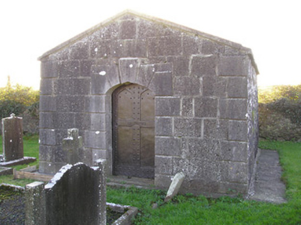 mausoleum109 yd
Explorer Tom Mausoleum in Abington has caught my eye in Abington, County Limerick. I bet a mausoleum with a name like that could keep me talking all afternoon; I'm already inventing a daft little scene for it, and I'll stop before it turns into history.
 Grave YardGraveyard · 124 ydComputer-made picture. It does not show this monument.
Explorer Tom Graveyard in Abington has caught my eye in Abington, County Limerick. I bet a graveyard with a name like that could keep me talking all afternoon; I'm already inventing a daft little scene for it, and I'll stop before it turns into history.
 Mausoleum in AbingtonMausoleum · 141 ydComputer-made picture. It does not show this monument.
Explorer Tom Mausoleum in Abington has caught my eye in Abington, County Limerick. I bet a mausoleum with a name like that could keep me talking all afternoon; I'm already inventing a daft little scene for it, and I'll stop before it turns into history.
 bridge161 yd
Explorer Tom Bridge in Abington has caught my eye in Abington, County Limerick. I bet a bridge with a name like that could keep me talking all afternoon; I'm already inventing a daft little scene for it, and I'll stop before it turns into history.
 Murroe Community PlaygroundChildren's playground · 1.7 miComputer-made picture. It does not show this playground.
Explorer Tom Murroe Community Playground has caught my eye in County Limerick. I bet a children's playground with a name like that could keep me talking all afternoon; I'm already inventing a daft little scene for it, and I'll stop before it turns into history.
 CastleCastle, motte and bailey · 1.9 mi
Explorer Tom Castle has caught my eye in Brittas, County Limerick. I bet a castle, motte and bailey with a name like that could keep me talking all afternoon; I'm already inventing a daft little scene for it, and I'll stop before it turns into history.
 Lady GardenGarden · 2.4 miComputer-made picture. It does not show this garden.
Explorer Tom Lady Garden has caught my eye in County Limerick. I bet a garden with a name like that could keep me talking all afternoon; I'm already inventing a daft little scene for it, and I'll stop before it turns into history.
More historic places in County Limerick · All of County Limerick

What do you know about this place?Tap to add a comment or ask a question