
Places near here
Photo credits
- National Inventory of Architectural Heritage
- Maker shown on the Wikimedia Commons file page · Public domain
- Gareth James, Geograph · CC BY-SA 2.0
- Oliver Dixon, Wikimedia Commons · CC BY-SA 2.0
- N Chadwick, Wikimedia Commons · CC BY-SA 2.0
- Donal Mac Coitir, Wikimedia Commons · CC BY 4.0
- N Chadwick, Geograph · CC BY-SA 2.0
- Joseph Mischyshyn, Geograph · CC BY-SA 2.0
- A.-K. D., Wikimedia Commons · CC BY-SA 4.0
- dougf, Wikimedia Commons · CC BY-SA 2.0
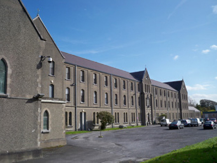 Galway-Mayo Institute of TechnologyFriary · 412 yd
Explorer Tom Galway-Mayo Institute of Technology is an old friary that now teaches art, which feels like a plot twist. It does its best impression of a monastery when nobody's looking for graffiti. Perfect spot to practice your serious face before class.
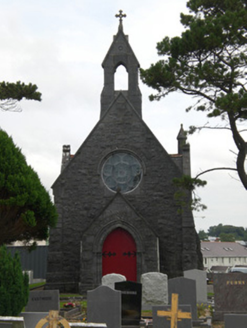 Bohermore CemeteryChurch/chapel · 712 yd
Explorer Tom Bohermore Cemetery smells like wet limestone and old regrets, according to my very sensitive nose, which I am absolutely not exaggerating about at all. It’s got two chapels standing there looking very serious while the dead folks do their own thing underground. Try not to step on anything that might be a toe!
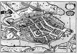 Siege of GalwaySiege · 1343 yd
Explorer Tom The Siege of Galway in County Galway has seagulls who gossip about the cannons like they were old neighbors arguing over fences. They claim the noise was unbearable and that the defenders were just trying to get some peace and quiet. Best visited with a curious kid and no timetable.
 Ballyloughane BeachBeach / strand · 1466 yd
Explorer Tom Ballyloughane Beach in County Galway is always getting picked on by the wind, which seems to think the sand isn’t quite firm enough yet. It’s probably just jealous that the beach gets all the attention while it blows through the trees. Stand there long enough and someone will ask if you're lost.
 Quincentennial FountainSculpture · 1685 yd
Explorer Tom Quincentennial Fountain in County Galway has a curse that only hits people who don’t wave at it. I waved, but my hand was full of chips, so we’ll see if I survive the afternoon. It’s a lovely spot for a snack with zero plans or regrets. Best enjoyed with a bag of chips and no plans.
 Eyre SquarePark · 1692 yd
Explorer Tom I came to Eyre Square expecting a patch of grass, and Galway handed me a travelling doorway. The space began outside a medieval town gate, where markets used the open ground; Mayor Edward Eyre gave the square to the city in 1710. A stone wall, different layouts and a few names followed. John F. Kennedy spoke here on 29 June 1963 while he was president of the United States, yet most Galwegians still call the place Eyre Square. Fair play to a name that can outlast a visiting president. Look for the Browne Doorway, originally part of a 1627 house on Abbeygate Street and moved here in 1905. That is one house part with more trips than my suitcase. The square is public ground in the city centre, beside the railway station and shopping streets, so you can wander in without a ticket. Circle the old doorway and ask where the rest of its house went.
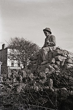 Padraic O'Conaire StatueMonument · 1693 yd
Explorer Tom The Padraic O'Conaire Statue in County Galway is standing there with that permanent look of someone who just remembered they left the stove on. It’s got a vibe that says 'I am deep, do not disturb my thoughts.' Have a wander and a wonder.
 Browne DoorwayVisitor information · 1702 yd
Explorer Tom Browne Doorway in County Galway was saved by a hero nobody remembers, probably because he forgot his own name. It sits quietly near Salthill, watching the world go by without asking for any recognition at all. It’s a solid spot that deserves more than just a passing glance. Stop the car, it's worth the hazard lights.
 GalwayHistoric town · 1.1 mi
Explorer Tom Galway in Townparks sits on the east bank of the River Corrib, built by Richard de Burgh in the 1230s on top of a stronghold. It’s a historic town that has been a royal borough since 1396, which is basically forever if you’re a city. Whisper a secret at it, it's kept worse secrets about its own walls.
 Mechanics InstituteMemorial · 1.1 mi
Explorer Tom Mechanics Institute has a superstition that if you touch the plaque twice, your engine will never stall. I’ve touched it three times and my car still makes noises, so maybe we’re all doomed. Ring your granny and tell her where you are.
 Merlin Park CastleCastle · 1.2 mi
Explorer Tom Merlin Park Castle sounds as if a wizard should pop out of the doorway, and I would buy the ticket if one did. The real tower house east of Galway dates to the fifteenth or sixteenth century. The Lynch family held it in the sixteenth, and people lived there into the mid-nineteenth. It was also called Doughiske Castle before the modern name stuck. A surviving fragment of a sheela na gig carving is recorded on the second floor, a detail to know without attempting to scramble inside. This is a protected old building near hospital grounds, so check lawful public access and keep out of unsafe masonry. View its shape from safe ground. The castle needed no spell to remain standing through all those changes of name and neighbour.
 Merlin CastleCastle, tower house · 1.2 mi
Explorer Tom Merlin Castle used to be called Doughiske until someone decided to rebrand it like a tech startup. It’s well-preserved and full of spiral stairs that will ruin your knees. Look up, the best bit is always higher than you think.
More archaeology and monuments in County Galway · All of County Galway

What do you know about this place?Tap to add a comment or ask a question