DDiscover AloneMapAbout

Megalithic structure in Ballon

Megalithic structure
Megalithic structure in Ballon
Representative picture, exact place not confirmed
Photo: Maker not stated on source page, www.pinterest.com · Report the wrong picture

The monument record does not grant public access. Check the route and ask the landowner before entering private land.

What do you know about this place?Tap to add a comment or ask a question

What you write will be public.

What is recorded here

According to O’Toole (1933, 235), within a roughly rectangular ‘garden’ (dims. c. 22m NW-SE; c. 17m NE-SW) there is, ‘a small enclosure which is called the “old Church-yard.” It is stated that it was formerly used for the burial of unbaptized children [CW013-071002-] and that within this enclosure there was, ‘a very…

Read the whole record
According to O’Toole (1933, 235), within a roughly rectangular ‘garden’ (dims. c. 22m NW-SE; c. 17m NE-SW) there is, ‘a small enclosure which is called the “old Church-yard.” It is stated that it was formerly used for the burial of unbaptized children [CW013-071002-] and that within this enclosure there was, ‘a very remarkable stone [CW013-071003-]’. The enclosure was levelled c. 1970 (Seaver and O’Neill, unpublished report, February 2022). According to an ASI field report (September 1988), ‘The stone formerly stood at the centre of a small enclosure defined by an earthen bank about 8m distant from the stone. To N of stone and inside [the] bank a trench (L c. 3m) with baked sides and filled with white ash or burnt bone was found during cultivation. There are no visible surface traces of the bank and the stone has been moved to the adjacent field boundary’. O’Toole describes the stone as being, ‘hexagonal in shape, five of the sides consisting of straight lines and the sixth is curved. It is six feet eight inches [2.03m] in length from east to west, and five feet ten inches [1.78m] from north to south; the depth is two feet [0.61m]. It is high in the centre and curves gently to the sides. In the middle of the upper surface there is a shallow basin-shaped hollow from which fourteen groovings or flutings, run to the outer edge. The sides of the stone seem to have been chiselled, but they are now overgrown with moss’ (ibid.). The ASI field report (September 1988) describes, a ‘Large granite boulder (c. 1.2m dim.). Upper surface has pattern of grooves, possibly artificial but forming no particular pattern although appearing to radiate from a central area’. A report in The Nationalist and Leinster Times 21 June 1947 describes the ‘Druid’s Altar’ as, ‘a burial stone of the cromlech group, resting on four supports sunk to foundation depth’ (Seaver and O’Neill, unpublished report, February 2022). The supports are also mentioned by Fr. Peadar Mac Suibhne, who describes how the boulder had, ‘stones under it like legs under a stool’ (ibid.). Prehistoric pottery was found in 1940, in rabbit burrows under the ‘stone’ (ibid.). Based on the available information it is not possible to classify the boulder with any certainty, though its association with prehistoric pottery and the reference to support stones suggests it is part of the megalithic tomb tradition or a boulder-burial.

From the National Monuments Service (Archaeological Survey of Ireland) record CW013-071003

Places near here

Photo credits
  • Graham Horn, Wikimedia Commons · CC BY-SA 2.0
  • Maker not stated on source page, en.wikipedia.org
  • National Inventory of Architectural Heritage
  • Maker not stated on source page, www.pinterest.com
  • Maker not stated on source page, commons.wikimedia.org
  • Maker not stated on source page, www.ampersandtravel.com
  • Colin Park, Geograph · CC BY-SA 2.0
  • Kmcnamee, Wikimedia Commons · CC BY-SA 4.0
Catholic Church of Saint Peter and Saint PaulChurch/chapel · 186 yd

Explorer Tom St Peter and Paul in Ballon is on a hill, which means it's always looking down on you while you climb. The reredos is…

St. Bridgets WellHoly well · 514 yd

Explorer Tom St. Bridgets Well in Ballon was dry on the map back in 1839 and still is now. Dry as a bone, just like my sense of…
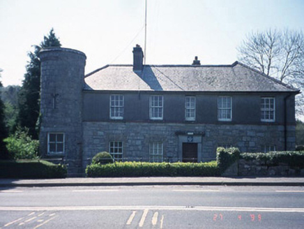
Ballon Garda Síochána StationRic barracks · 644 yd

Explorer Tom Ballon Garda Station has a corner tower that’s seen more crime than your average soap opera. Bring your own legend…

Ballykealey HouseCountry house · 1329 yd

Explorer Tom Ballykealey House in Ballykealey is a three-storey Tudor monster that would cope perfectly on a reality show by…

Ballinvally HouseFarm house · 1357 yd

Explorer Tom Ballinvally House in Ballinvally is derelict and looking for a new manager, with round-headed doors that seem to be…

Ballon GAA pitchGAA ground · 1.0 miCastle Grace (in Ruins)Castle, unclassified · 1.4 mi

Explorer Tom Castle Grace is gone, replaced by outbuildings that don’t even have the decency to look medieval. A stubborn bird…

Holy well in Milltown (idrone East By.)Holy well · 1.5 mi

Explorer Tom Holy well in Milltown was called 'Brides Well' once, but the field is drained and now unlocated, like a ghost with a…

Graveyard in BallyvealGraveyard · 1.6 mi

Explorer Tom Graveyard in Ballyveal is small, walled, and has church foundations peeking through like they're shy. Its favourite…

CastleCastle, unclassified · 1.6 mi

Explorer Tom Kilknock Castle was 'out of repaire' in 1650, which is basically ancient history for a tired building. It’s probably…

Altamont Gardens MapVisitor information · 2.0 mi

Explorer Tom Altamont Gardens Map in County Carlow would bring its own compass to a party and still get lost. It’s all curves and…

Kilbride GAA pitchGAA ground · 2.4 mi

More archaeology and monuments in County Carlow · All of County Carlow

Add to this placeAdd a picture Add a detailed tip Add a story

Explore the map1,095,414 places to discover

Next place · or swipeCatholic Church of Saint Peter and Saint Paul