
What is recorded here
From OpenStreetMap (© OpenStreetMap contributors) n3792006449
Places near here
Photo credits
- Anne Burgess, Wikimedia Commons · CC BY-SA 2.0
- National Inventory of Architectural Heritage
- Kenneth Allen, Geograph · CC BY-SA 2.0
- A McCarron, Wikimedia Commons · CC BY-SA 2.0
- Eric Jones, Geograph · CC BY-SA 2.0
- louise price, Geograph · CC BY-SA 2.0
- Joseph Mischyshyn, Wikimedia Commons · CC BY-SA 2.0
- Kenneth Allen, Wikimedia Commons · CC BY-SA 2.0
 CroaghnamaddyMountain / peak · 1734 yd
Explorer Tom Croaghnamaddy in County Donegal is basically just a very arrogant hill that thinks it's a mountain. I'd bet my last pint there's a secret bakery up there, so bring biscuits, every good story needs biscuits.
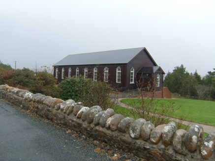 Saint Patrick's Catholic ChurchChurch/chapel · 1.4 mi
Explorer Tom Saint Patrick's Catholic Church in Meenacross looks like a sturdy wooden box from the outside. Built in 1930, its timber cladding hides a surprisingly bright, colorful interior. I reckon stepping inside feels like opening a plain gift to find confetti.
 public house1.5 mi
Explorer Tom Public house in Dunglow is throwing a party from 1880 that never ended. This semi-detached gem has dormer windows with round heads and delicate bars. Grab a pint for me, but don't let the landlord know I told you!
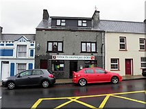 Teach Owenie BánPub · 1.6 mi
Explorer Tom Teach Owenie Bán in Dungloe has a sign that’s falling off the wall, which is very on-brand for the pub. The Irish name is fancy, but the pints are likely mediocre. Keep an eye out for ghosts.
 Teach Leanna BeedíPub · 1.6 mi
Explorer Tom Teach Leanna Beedí is another fancy Irish name for a pub that likely serves mediocre beer. It’s right next door to Mulhern's, so the rivalry must be fierce. Check if they throw peanuts across the boundary.
 Lough Aghnish Promontory FortPromontory fort, inland · 2.1 mi
Explorer Tom Lough Aghnish Promontory Fort cuts off a peninsula with a stone wall that has a weird, angled entrance. The base is solid, but the top looks like modern repairs. It’s a bit of a puzzle why they built it exactly there.
 Drumlaghdrid HillMountain / peak · 3.0 mi
Explorer Tom Drumlaghdrid Hill stands in County Donegal with its access details currently unknown. A photograph shows the B7905 road climbing south-eastwards across its flank, six kilometres north of Lettermacaward. It is a bit cheeky for a hill to have such a well-documented road climbing up its side while still keeping its own path a secret!
 DooeyOfficial bathing water · 3.9 mi
Explorer Tom Dooey seems to have let the Gweebarra estuary and a headland book its two ends. Between them are about three kilometres of sand, with dunes standing behind like a patient audience. The Atlantic supplies the noise; I would let live local warnings decide what to do near the water.
 Inis Mhic an DoirnIsland · 4.6 mi
Explorer Tom Inis Mhic an Doirn has that 'don't touch' energy radiating off it like Wi-Fi. There’s a derelict building nearby that looks haunted by bad decisions. Mind the nettles, they're the real guards here and they bite back.
Hook Point / Pointe an DuáinHeadland · 4.8 miExplorer Tom Hook Point makes a weird humming sound at night that sounds like a tuba falling down stairs. It’s quite embarrassing for the whole headland, really. Bring your worst joke, because this place has definitely heard worse.
 An tÍochtarIsland · 5.8 mi
Explorer Tom An tÍochtar is out here looking like it wants a nap, tucked away in County Donegal. Snap one photo, then put the phone away and actually look, because my eyes are starting to cross from squinting.
 Cairn, LoughanurePublicly named cairn · 5.9 mi
Explorer Tom Cairn, Loughanure is a place where the name suggests a connection to water and perhaps a specific local story. I imagine it’s one of those spots that has been part of the landscape for a long time, maybe used by people who lived nearby. It’s a name that makes you think about how places get their names.
More mountains and hills in County Donegal · All of County Donegal

What do you know about this place?Tap to add a comment or ask a question