Places near here
Photo credits
- National Inventory of Architectural Heritage
- Tim-daniel-elise-barbara, Wikimedia Commons · CC BY-SA 4.0
- Vadim Manuylov, Wikimedia Commons · CC BY-SA 3.0
- Suckindiesel, Wikimedia Commons · CC BY-SA 3.0
- Irlpol, Wikimedia Commons · CC BY-SA 3.0
- William Murphy, Wikimedia Commons · CC BY-SA 3.0
- Suckindiesel, Wikimedia Commons · CC BY 2.5
- Colin Park, Geograph · CC BY-SA 2.0
- Gareth James, Geograph · CC BY-SA 2.0
- Patrick Keegan, Wikimedia Commons · CC BY 4.0
- The original uploader was Irishpunktom at English Wikipedia ., Wikimedia Commons · CC BY-SA 3.0
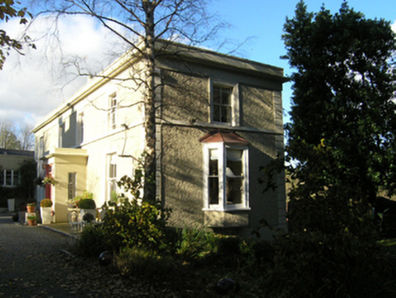 FlorencevilleHouse · 37 yd
Explorer Tom Florenceville was likely built for a mill owner in 1826 and overlooks the ruins of Shanganagh Castle. It’s got a cruciform plan that’s perfect for getting lost in. The ruins nearby are shard-like, so watch out for your ankles if you wander too close!
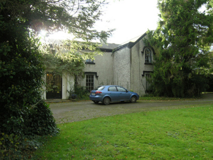 BeechlandsHouse · 60 yd
Explorer Tom Beechlands in Shanganagh thinks it survived some massive storm, but it was probably just a drizzle. It’s part of a pair, so it needs its mate to feel important. A quick nod from you will do the trick.
 Ballybrack DolmenArchaeological place · 487 yd
Explorer Tom This dolmen has strong opinions about the road leading to it, mostly that it’s too busy. It’s been standing there judging everyone for centuries. Stand there long enough and someone will ask if you're lost.
 Monterey Cypress1358 yd
Explorer Tom This Monterey Cypress in County Dublin is definitely listening to a fiddler who never stops playing. The music is stuck in its branches. Bring a friend who talks too much and let the place shut them up.
 Shanganagh CastleCastle, unclassified · 1.0 mi
Explorer Tom Shanganagh Castle (Unclassified) had two cannon shots pulled out before they rebuilt it. That’s all we know for sure, so I’m guessing the neighbours are still arguing about who fired first. Bring the dog, it'll have opinions.
 Martello Tower1.1 mi
Explorer Tom Martello Tower in Killiney. Located just under a quarter of a mile inland, this tower is nestled in an urbanized area of housing. It has been fully restored, so it looks less like a relic and more like a very serious garden ornament.
.jpg/250px-Killiney_Beach_-_panoramio_(3).jpg "Photo: William Murphy, Wikimedia Commons · CC BY-SA 3.0") Killiney BeachBeach / strand · 1.3 mi
Killiney BeachBeach / strand · 1.3 miExplorer Tom Killiney Beach in County Dublin would bring a massive bag of stones and a dramatic story about its past to any party. The exclusion zone for boats is just there to keep the drama from getting too out of hand. Count the crows, then count again.
 Puck's CastleCastle · 1.5 mi
Explorer Tom Puck's Castle in County Dublin sounds like something from a fairy tale, which fits perfectly since we're in Ireland. It's in Shankill, so if you see any mischievous sprites, just nod at them politely and move on.
 Mapas MonumentHeritage attraction · 1.8 mi
Explorer Tom Mapas Monument in County Dublin was built back in 1742 because the walks were too hard. John Mapas did it, so we owe him one. Stand next to it and look like you know the history!
 White Rock, Killiney BeachBeach / strand · 1.8 mi
Explorer Tom White Rock, Killiney Beach in County Dublin is accessed by 100 steps, which is basically a cardio workout disguised as a beach trip. The nudists are on the left, so just keep your eyes forward and try not to make eye contact unless you're ready.
 Proclamation of the Irish RepublicMemorial · 1.9 mi
Explorer Tom Proclamation of the Irish Republic is a big deal in County Dublin. It’s a memorial to history changing. The picture looks nice from a distance. Get closer and listen to the echoes of old speeches.
 Dalkey HillMountain / peak · 2.1 mi
Explorer Tom Dalkey Hill used to be run by a matchmaker who charged extra if you had to walk all the way up the slope. She’s gone now, but the hill still looks like it’s judging everyone’s outfit choices from above. Have a look and decide if I was lying.
More historic places in County Dublin · All of County Dublin

What do you know about this place?Tap to add a comment or ask a question