
What is recorded here
A small settlement is marked on the Down Survey (1655-6) Barony map on the E side of the Sullane River and in the vicinity of the present day town of Macroom (Maigh Chromtha). The terrier of the Down Survey Map of Muskerry Barony recorded that, 'The places of note are the towne and castle of Macrumpre [Macroom] being…
Read the whole record
From the National Monuments Service (Archaeological Survey of Ireland) record CO071-156
Places near here
Photo credits
- Postdlf, Wikimedia Commons · CC BY-SA 3.0
- National Inventory of Architectural Heritage
- Richard Fensome, Geograph · Creative Commons Attribution-ShareAlike 2.0
- Maker not stated on source page, readymap.irish
- Joebater at English Wikipedia, Wikimedia Commons · CC BY-SA 3.0
- Lynch & Associates project gallery; individual photographer not stated, lynchconsultingengineers.com
- Kmcnamee, Wikimedia Commons · CC BY-SA 4.0
- Maker not stated on source page, pixels.com
- Jim Woodward-Nutt, Wikimedia Commons · CC BY-SA 2.0
 Macroom Market HouseMarket house · 24 yd
Explorer Tom Macroom Market House in Sleveen East is all sandstone swagger and limestone flexing. It sits right there dominating the…
 Allid Irish BankBank/financial institution · 40 yd
Explorer Tom Allid Irish Bank in Lackenduff thinks it’s still the boss of Macroom’s square. Built around 1900, it’s got render…
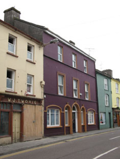 Castleville HouseHouse · 77 yd
Explorer Tom Castleville House in Sleveen East has been sitting on South Square since 1880, showing off its tripartite door like…
 W.j. TwohigHouse · 83 yd
Explorer Tom W.J. Twohig House in Sleveen East has timber consoles that look like they’re trying too hard to impress you. It’s all…
 A. GoldenHouse · 103 yd
Explorer Tom A. Golden in Sleveen East is living over the shop like it's 1895 and no one has told it otherwise. Its name actually…
 Saint Colman's Church (Macroom)Church/chapel · 140 yd
Explorer Tom Saint Colman's Church (Macroom) is a Gothic-Revival masterpiece from 1825 that got a chancel added in 1869. It’s…
 Church in Sleveen EastChurch · 140 yd
Explorer Tom Church in Sleveen East nearly made the news when a tourist claimed to have seen a bishop dancing in the tower. It’s a…
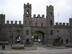 Battle of MacroomBattle · 233 yd
Explorer Tom The Battle of Macroom is constantly trying to one-up its more famous cousin next door by claiming it had better weather…
 Bishop McEgan Park, MacroomGAA ground · 268 yd
 Tom Creedon Park, MacroomGAA ground · 1060 yd
 Fairy fort / earthen ringfort in Sleveen EastFairy fort / earthen ringfort · 1309 yd
Explorer Tom Fairy fort / earthen ringfort in Sleveen East is an oval saucer overlooking two rivers. The stone-faced scarp looks…
 Bealick MillVisitor attraction · 1441 yd
Explorer Tom Bealick Mill would teach history like a strict teacher who only uses one-liners and expects you to already know the…
More archaeology and monuments in County Cork · All of County Cork

What do you know about this place?Tap to add a comment or ask a question