
What is recorded here
From the National Monuments Service (Archaeological Survey of Ireland) record SL041-017
Places near here
Photo credits
- Maker not stated on source page, commons.wikimedia.org
- Maker not stated on source page, www.derbytelegraph.co.uk
- Maker not stated on source page, www.tripadvisor.es
- National Inventory of Architectural Heritage
- Maker not stated on source page, ca.pinterest.com
- Maker not stated on source page, www.alamy.com
- Maker not stated on source page, de.wikipedia.org
- Maker not stated on source page, www.pinterest.com
- Kmcnamee, Wikimedia Commons · CC BY-SA 4.0
- N Chadwick, Geograph · CC BY-SA 2.0
- Rob Hurson, Wikimedia Commons · CC BY-SA 4.0
 Earthwork in CarrickardEarthwork · 205 yd
Explorer Tom Earthwork in Carrickard is currently being managed by a very confident dog named Buster who thinks he’s the landlord.…
 Holy well in Treanmore (tirerrill By.)Holy well · 487 yd
Explorer Tom Holy well in Treanmore is hiding a treasure that is definitely just an old biscuit tin wrapped in moss. Nobody has…
 Kilmactranny GraveyardGraveyard · 1033 yd
Explorer Tom There’s a tall tale about Kilmactranny Graveyard having a hidden tunnel straight to the local pub for quick escapes.…
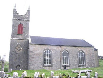 Saint Thomas's Church (Kilmactranny)Church/chapel · 1094 yd
Explorer Tom Saint Thomas's Church in Carrickard has very strong opinions about modern buildings, mostly that they look like…
 Stuckerd (Pillar Stone)Standing stone · 1154 yd
Explorer Tom Stuckerd in Carrickard is officially gone, so the fairies now argue about who gets to park their carts there. It used…
 Graveyard in KilkereGraveyard · 1246 yd
Explorer Tom The Kilkere graveyard has a family tree mostly made up of electricity pole workers who found bones in 1990. It sits…
 Fairy fort / earthen ringfort in Dromore (tirerrill By., Kilmactranny Ed)Fairy fort / earthen ringfort · 1258 yd
Explorer Tom Building this fairy fort in Dromore must have taken at least forty thousand cups of tea, judging by how much mud is…
 Fairy fort / earthen ringfort in CarrickardFairy fort / earthen ringfort · 1281 yd
Explorer Tom Fairy fort / earthen ringfort in Carrickard was built by someone who really didn’t care about straight lines or right…
 Geevagh GAAGAA ground · 2.2 miKilronan Park, St. Ronan's GAAGAA ground · 2.2 mi
 Barroe NorthMountain / peak · 2.3 mi
Explorer Tom Barroe North thinks it’s cooler than its famous neighbour, but honestly, who are we to judge? It’s got that mysterious…
 Bricklieve MountainsMountain / peak · 5.1 mi
Explorer Tom The Bricklieve Mountains have had so many names they should really be asking for a royalty check. It’s like they kept…
More archaeology and monuments in County Sligo · All of County Sligo

What do you know about this place?Tap to add a comment or ask a question