
What is recorded here
From OpenStreetMap (© OpenStreetMap contributors) w1526839820
Places near here
Picture notes
- Computer-made picture. It does not show this monument.
- National Inventory of Architectural Heritage
- Computer-made picture. It does not show this playground.
- Computer-made picture. It does not show this mountain top.
- P L Chadwick, Wikimedia Commons · CC BY-SA 2.0
- Tiger, Geograph · CC BY-SA 2.0
- Charles W Glynn, Wikimedia Commons · CC BY-SA 2.0
 LissaguttaHachuredFairy fort / earthen ringfort · 317 ydComputer-made picture
 Fairy fort / earthen ringfort in Ballycullane LowerFairy fort / earthen ringfort · 400 ydComputer-made picture
 Fairy fort / earthen ringfort in KilmurrilyFairy fort / earthen ringfort · 440 ydComputer-made picture
Explorer Tom Fairy fort / earthen ringfort in Kilmurrily would teach history by showing you where it used to be before the plough ate it. It’s basically a ghost of a bank, haunting the memory of the field. Go on, count the windows and get it wrong like I did.
 Lissaritter - HachuredFairy fort / earthen ringfort · 461 ydComputer-made picture
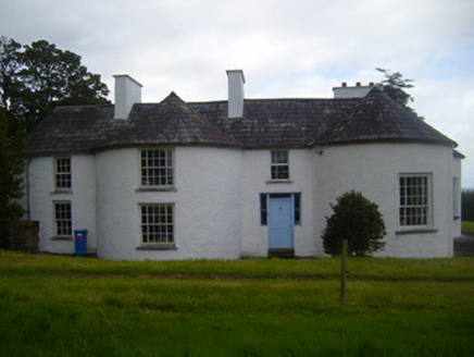 Fort ShannonHouse · 1656 yd
 Ballydonohoe HouseHouse · 1.1 mi
Explorer Tom Ballydonohoe House in Ballydonohoe is losing its mind because the wind keeps singing showtunes at it. It was built to be seen from the river, so it's always posing for boats that aren't there. Find a local and ask them where the ghosts are sleeping.
 Tarbert PlaygroundChildren's playground · 1.8 miComputer-made picture
 Glin playgroundChildren's playground · 2.2 miComputer-made picture
 KnockroeMountain / peak · 3.6 miComputer-made picture
Explorer Tom Knockroe, a peak that’s as ancient as the stones that dot the landscape of County Clare.
 Clonderalaw BayBay · 4.2 mi
Explorer Tom Clonderalaw Bay offers a gentle curve of water in County Clare, perfect for spotting seabirds from the shore.
 St Senan's WellSpring · 5.8 mi
Explorer Tom St Senan's Well marks his birthplace on the duck field. Born in 488 AD and still making waves today. Check for any ducks hanging around, they might be his ancestors in disguise.
 Ballymacrinan BayBay · 5.8 mi
Explorer Tom Ballymacrinan Bay nestles near Moyne in Kilrush, a calm bay where the waves seem to slow down for a chat.
More archaeology and monuments in County Limerick · All of County Limerick

What do you know about this place?Tap to add a comment or ask a question