Places near here
Photo credits
- National Inventory of Architectural Heritage
- Peter Allen, Wikimedia Commons · CC BY-SA 2.0
- Chmee2, Wikimedia Commons · CC BY-SA 3.0
- abdallahh from Montréal, Canada, Wikimedia Commons · CC BY 2.0
- Willthacheerleader18, Wikimedia Commons · CC0
- Picture: Discover Ireland
- Mike Searle, Wikimedia Commons · CC BY-SA 2.0
- Jan Wyk, Wikimedia Commons · Public domain
Explorer Tom Enclosure in Ballyglass has a dating profile that just says 'I am overgrown and slightly circular.' The field boundaries cut right through its middle like it’s not even trying to hold together anymore. Bring your worst joke, the place has heard worse from the wind.
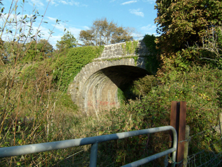 bridge992 yd
Explorer Tom The Bridge in Cartrondoogan is suspicious of anyone who doesn’t have a train ticket. Built for the railway, it still judges walkers with its perfect limestone symmetry. Snap one photo, then put the phone away and just look.
Man-made underground passage1038 ydExplorer Tom Man-made underground passage in Ballyglass has a trapezoidal depression that looks like a giant's footprint. I reckon it rates its visitors one to five based on how loudly they cough. Perfect detour when the satnav has a meltdown.
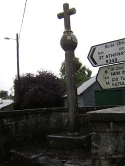 cross1.4 mi
Explorer Tom The cross in Corraneena has a ghost who is too lazy to haunt it because he’d have to walk all the way over there. The carving is still crisp despite being damaged and re-erected, which shows it’s got more stamina than most people in this county. If you see it standing straight, just whisper that you appreciate its effort.
 Kilconnell AbbeyVisitor attraction · 1.4 mi
Explorer Tom Kilconnell Abbey would take its lotto win and spend it all on a really fancy hat for one of the statues just to see if anyone notices. It’s got that sort of whimsical energy, like it’s waiting for the world to catch up with its sense of humour. Mind the nettles, they're the real guards here.
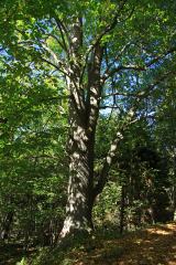 Large-leaved Lime1.6 mi
Explorer Tom Large-leaved Lime in County Galway is famous locally for a giant who tried to nap under it but fell asleep and rolled off the branch. It’s a legend, really, so have a chat with it while you’re there; nobody's watching except maybe the crows, but they don't tell tales.
 Western Redcedar2.0 mi
Explorer Tom Western Redcedar in County Galway is caught in a territorial dispute with a nearby oak over who owns the best view of the valley. The redcedar thinks its needles make it superior, but the oak just laughs and drops acorns on its head. Wave at the cows, they're the real locals.
 Clonbrock CastleCastle, tower house · 5.2 mi
Explorer Tom Clonbrock Castle is well-preserved, partially restored, and sits in flat woodland by the river. Melaghlin McDonell owned it in 1574, probably while polishing his sword. Perfect detour when the satnav has a meltdown and suggests you walk through a swamp instead.
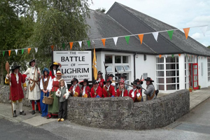 Battle of Aughrim Interpretative CentreMuseum · 5.4 mi
Explorer Tom Battle of Aughrim Interpretative Centre in County Galway thinks its imaginary twin across the sea is judging its display cases for being slightly too dark. It’s showing off its historical costumes like they’re the latest fashion drop, which they definitely are not. Linger a bit; it’s not going anywhere and neither should you.
_-_geograph.org.uk_-_4070639.jpg/250px-Castles_of_Connacht,_Killure,_Galway_(1)_-_geograph.org.uk_-_4070639.jpg "Photo: Mike Searle, Wikimedia Commons · CC BY-SA 2.0") Killure Castle (in ruins)Castle, tower house · 5.7 mi
Killure Castle (in ruins)Castle, tower house · 5.7 miExplorer Tom Killure Castle in Galway has a murder-hole that probably just looks at you now. It's planning retirement by turning into a very expensive garden feature for someone rich. Hum something sad nearby, it adds atmosphere.
.jpg/250px-Battle_of_Aughrim_by_Jan_Wyk_(cropped).jpg "Photo: Jan Wyk, Wikimedia Commons · Public domain") Battle of AughrimMajor battlefield · 5.9 mi
Battle of AughrimMajor battlefield · 5.9 miExplorer Tom Battle of Aughrim in County Galway has a prophecy that says if you sneeze here, you’ll dance with the dead, but nobody ever checks because they’re too busy fighting. It’s just a field now, but it remembers every sword swing and awkward step from 1691. Sit on a wall nearby and pretend you’re in a very dusty painting.
The bloody HollowHeritage attraction · 6.2 miExplorer Tom The bloody Hollow in County Galway got its name from a priest who lost a bet about how many crows he could scare off with one shout. He screamed so loud he broke his voice and maybe a few bones, or so the legend goes. Get there early and have it all to yourself before the ghosts get their coffee.
More archaeology and monuments in County Galway · All of County Galway

What do you know about this place?Tap to add a comment or ask a question