
Places near here
Photo credits
- National Inventory of Architectural Heritage
- Mike Searle, Geograph · CC BY-SA 2.0
- dougf, Geograph · CC BY-SA 2.0
- SlaineMacRoth, Wikimedia Commons · CC BY-SA 4.0
- El Gringo ( talk ) ( Uploads ), Wikimedia Commons · CC BY-SA 3.0
- Gordon Hatton, Wikimedia Commons · CC BY-SA 2.0
Explorer Tom Irish National Forestry Foundation is a nature reserve that gets tipsy after three pints of rainwater. It will tell you secrets about the ringforts if you listen closely enough. Ten minutes here and you will have a yarn for the pub.
Castle RockNamed rock · 2.0 miExplorer Tom Castle Rock caused such a massive row in the parish last Tuesday that three people are still not speaking to each other. Everyone has an opinion on whether it looks more like a castle or just a very angry boulder. Take a breath of that air, it's older than your car.
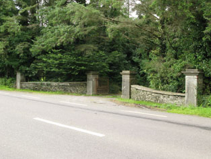 Carrigmore HouseGates/railings/walls · 2.2 mi
Explorer Tom Carrigmore House has an entrance gateway that screams ‘look at me’ with its carved limestone details, probably because the house itself is too shy to speak up. It’s like a bouncer who knows all the VIPs but still checks IDs. Keep your eyes peeled for any aristocratic nonsense hiding behind those fancy carvings.
 Fort RobertArchaeological place · 2.2 mi
Explorer Tom Fort Robert is an archaeological site where a prophecy said a dragon would land here in 1994, but it never did and everyone just forgot about it afterwards without making a fuss. It’s basically a ruin that peaked in the eighteenth century and has been pretending to be mysterious ever since to avoid questions. Bring biscuits, every good story needs biscuits.
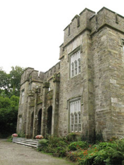 Kilcascan CastleCountry house · 2.3 mi
Explorer Tom Kilcascan Castle in Kilcaskan was built around Joseph Daunt’s second wedding, which suggests he needed a bigger house to hide from his first wife. It’s thought to be by the Pain brothers, or maybe just local guys named Hickie. Ten minutes h
 Tower (in Ruins)Bawn · 2.7 mi
Explorer Tom Tower in Ballynacarriga is just fragmentary bawn remains next to the main castle. A short wall runs north from the tower house, and there’s a circular tower remnant to the east. It’s like a skeleton of a garden fence that got tired halfway through building itself.
 Ballynacarriga CastleCastle, tower house · 2.7 mi
Explorer Tom Ballynacarriga Castle is a four-storey tower house overlooking the lough. It has a spiral stair, vaulted lobby, and murder hole. The top floor was used as a chapel later on. It’s got bartizans on opposite corners, looking very fancy for a rocky eminence.
 Sheela-na-gig in Ballynacarriga (carbery East (eastern Div.) By.)Sheela-na-gig · 2.7 mi
Explorer Tom Sheela-na-gig in Ballynacarriga By.) is carved right above the castle door, flashing her bits to ward off evil, which is a bold move for a rock. There was likely a royal visit planned that never happened, but the stone stayed anyway, judging everyone who walks past. Best enjoyed with a bag of chips and no plans.
Graveyard in Dunmanway NorthGraveyard · 3.3 miExplorer Tom Graveyard in Dunmanway North has a family tree that’s mostly made up of rumours and one very confused cousin who moved away. It’s got that mysterious aura that makes you wonder if it’s hiding something or just really bad at small talk. Whisper a secret at it, it's kept worse.
Mount GunneryMountain / peak · 3.4 miExplorer Tom Mount Gunnery in County Cork has a hidden message carved into its stones if you know where to look. It’s probably just someone’s name from 1950, but it feels ancient and important anyway. Make up your own legend and I'll swear it's true.
 Kilmichael AmbushAmbush · 4.8 mi
Explorer Tom The Kilmichael Ambush has a secret talent for making you feel like you’re walking through a very aggressive history book that keeps popping up in your peripheral vision to check if you’re paying attention. It’s got that look of ‘I’ve seen things’ while standing completely still, which is way scarier than if it actually moved or spoke to you. Count the crows, then count again.
 Kilmichael Ambush SiteMonument · 4.8 mi
Explorer Tom Kilmichael Ambush Site in County Cork has a rivalry with every other ambush site because they all think theirs was the cleverest one ever pulled off. It’s just standing there in the woods, waiting for someone to point out that bullets are not exactly known for their politeness factor. Perfect spot to practise your best tour-guide voice.
More archaeology and monuments in County Cork · All of County Cork

What do you know about this place?Tap to add a comment or ask a question