
What is recorded here
From the National Monuments Service (Archaeological Survey of Ireland) record LI037-005
Places near here
Photo credits
- Mike Searle, Geograph · CC BY-SA 2.0
- Brendan Gleeson / The Echo (explicit article photo credit), www.echolive.ie
- National Inventory of Architectural Heritage
- Maker not stated on source page, www.flickr.com
- Maker not stated on source page, www.dreamstime.com
- Maker not stated on source page, commons.wikimedia.org
- Maker not stated on source page, www.gettyimages.com
- Willow, Wikimedia Commons · CC BY 2.5
- Maker not stated on source page, www.gettyimages.ca
- Kmcnamee, Wikimedia Commons · CC BY-SA 4.0
 Knockaderry HouseCountry house · 704 yd
Explorer Tom Knockaderry House in Knockaderry is derelict but still holding onto its fine slate roofs and iron rainwater goods. It…
 Knockaderry GAA pitchGAA ground · 922 yd
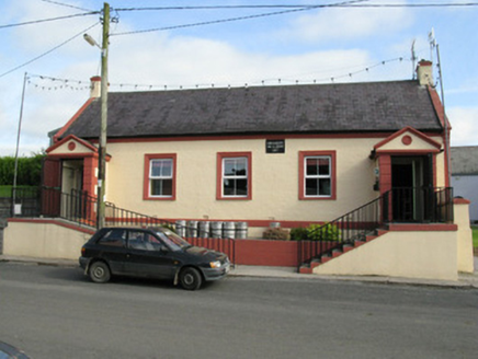 Knockaderry Hall and LibraryHall · 1051 yd
Explorer Tom Knockaderry Hall and Library in Ballybrown is dressed up with chevron motifs like it’s heading to a very serious…
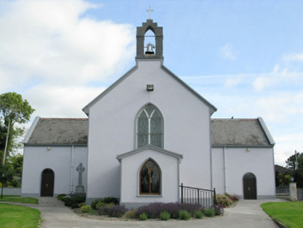 Saint Munchin's Catholic ChurchChurch/chapel · 1081 yd
Explorer Tom Saint Munchin's Catholic Church in Knockaderry is dominated by a dog that thinks it’s in charge. It sits on an elevated…
 Fairy fort / earthen ringfort in Loghill (connello Lower By.)Fairy fort / earthen ringfort · 1091 yd
Explorer Tom Fairy fort / earthen ringfort in Loghill would be the uncle who stands too close and talks too loud at weddings. It’s…
 Flat cemetery in KnockaderryFlat cemetery · 1327 yd
Explorer Tom Flat cemetery in Knockaderry handles nosey neighbours by staying flat and unexciting until they dig too deep.…
 Fairy fort / earthen ringfort in Ballyallinan South,ballybrown (glenquin By.)Fairy fort / earthen ringfort · 1340 yd
Explorer Tom Ballybrown was saved by a hero who just stood there looking confused until the invaders got bored. It’s so overgrown…
 Fairy fort / earthen ringfort in Ballybrown (glenquin By.)Fairy fort / earthen ringfort · 1641 yd
Explorer Tom Fairy fort / earthen ringfort in Ballybrown has a feud with the neighbours over who owns the best view. The avenue…
 CastleCastle, tower house · 1.6 mi
Explorer Tom Ballyallinan Castle would cope fine on a reality show by doing absolutely nothing for hours. It’s five floors of arched…
 European ash1.7 mi
Explorer Tom European ash makes a creaking sound at night that sounds exactly like someone judging your life choices. It’s just a…
 Mapped cemeteryCemetery · 5.5 mi
Explorer Tom Mapped cemetery in County Limerick is sick of being asked how deep the graves are, because the answer is always 'deeper…
 Páirc na nGael, MonageaGAA ground · 5.8 mi
More archaeology and monuments in County Limerick · All of County Limerick

What do you know about this place?Tap to add a comment or ask a question