
Places near here
Photo credits
- National Inventory of Architectural Heritage
- Stan Courtney, Geograph · CC BY-SA 2.0
- Malene Thyssen, Wikimedia Commons · CC BY-SA 3.0
- D Gore, Geograph · CC BY-SA 2.0
- Eric Jones, Wikimedia Commons · CC BY-SA 2.0
- Deadstar, Wikimedia Commons · CC BY-SA 4.0
 Coppanagh MillsChimney · 1208 yd
Explorer Tom Coppanagh Mills chimney stands alone like a grumpy stone giant, built back in 1860 for grinding corn and flax. It’s totally lost its way without the mills, so give it a little wave as you pass by.
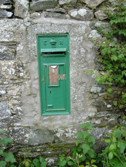 post box1268 yd
Explorer Tom Post box in Coppanagh is hiding a message in its stones that says 'the milkman owes me money' or something equally important and mysterious. It’s stuck on the corn mill wall like a badge of honor from when rural life actually had some real drama going on. Look closely at the cast iron.
Embanked enclosureBawn · 1480 ydExplorer Tom Embanked enclosure at Pottle East is a rectangular area that the local sheep think is just another field to graze. It's been incorporated into a boundary, so it's basically part of the fence now. Sit on a wall near it and pretend you're in a painting.
BarraghMountain / peak · 1508 ydExplorer Tom Barragh is stuck in a property dispute with its shadow over who owns the sunset view, and neither party is willing to budge an inch. It’s got that territorial, 'this is my rock' attitude that makes it feel very exclusive indeed. Bring curiosity, leave with a better story than mine.
Bawn in DrumsheilBawn · 1.4 miExplorer Tom Bawn in Drumsheil sits on Castle Hill, which is a bit cheeky for a bawn. Piers Field nearby hints at walls that vanished into the forest fog. Have a look and decide if I was lying.
Giant's GraveArchaeological place · 2.1 miExplorer Tom Giant's Grave has a family tree that is mostly made up of rocks pretending to be relatives from way back in the day. Look up, the best bit is always higher than you think, so stop staring at the ground and see the sky instead.
 Carn WoodForest · 3.9 mi
Explorer Tom Carn Wood in County Monaghan is throwing a massive history party that nobody invited you to, except Saint Patrick who definitely complained about the noise. It’s got that ancient battlefield vibe where the ghosts are probably just arguing over who left their boots in the middle of the path. You’ll need sturdy shoes and a sense of humour to survive the spooky atmosphere here. Bring a jacket, it's a
Giants GraveArchaeological place · 4.1 miExplorer Tom Over here, another Giants Grave is absolutely losing its mind over the postman, convinced he’s stealing bones to make soup or something equally ridiculous. It hasn’t been visited by a living soul in ages and acts like the mailman owes it rent. Bring a flask of something warm and a story to swap.
 European Beech4.2 mi
Explorer Tom Another European Beech here remembers the day a goat tried to climb it and failed spectacularly. The whole valley saw the disaster unfold. Tell it a joke, it's been a long time since anyone did.
 Flagpole HillMountain / peak · 4.8 mi
Explorer Tom Flagpole Hill is the sort of peak that clearly had a mother-in-law design it, giving it that distinct look of permanent, passive-aggressive disappointment. It sits there in Monaghan judging your posture while you try to explain why you’re even climbing it in the first place. Stick around for the light changing, it's a show.
 Dawson MonumentMonument · 5.2 mi
Explorer Tom Dawson Monument in County Monaghan is the other one, and I’m convinced a very serious dog is actually in charge of the whole operation. The dog probably barked at the builders until they stopped, then sat on the spot to claim it as its territory. It’s got that 'I own this patch of grass' energy, even if it’s just stone. Visit, then text me what you think. I'll pretend to read it.
 Fin Mc Cools FingersStone row · 5.9 mi
Explorer Tom Fin Mc Cools Fingers in Shantemon are said to be the hand of a giant who got stuck in the mud while trying to steal a sheep and never managed to get free. The stones are graded in height so they look like fingers, which is a bit creepy if you think about it too hard. Go back in winter, it's a different animal.
More mountains and hills in County Cavan · All of County Cavan

What do you know about this place?Tap to add a comment or ask a question