What is recorded here
Places near here
Photo credits
- National Inventory of Architectural Heritage
- Joseph Mischyshyn, Geograph · CC BY-SA 2.0
- Rossographer, Wikimedia Commons · CC BY-SA 2.0
- C.B.Doak (user Zorba the Geek ), Wikimedia Commons · Public domain
- David Dixon, Geograph · CC BY-SA 2.0
- Maker named on the Wikimedia Commons picture page · CC BY-SA 2.5
- Maker named on the Wikimedia Commons picture page · Public domain
- Humphrey Bolton, Geograph · CC BY-SA 2.0
- Colin Park, Wikimedia Commons · CC BY-SA 2.0
- Rod Grealish, Geograph · CC BY-SA 2.0
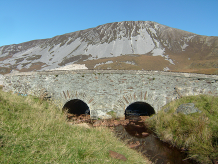 Droichead na nDeor [The Bridge of Tears]Bridge · 1488 yd
Explorer Tom Droichead na nDeor [The Bridge of Tears] was built around 1820 on a mountain road. A poem beside it says friends and relations came this far with people leaving for foreign lands. I keep reading its plainest line: 'Here was the separation.' Some places need their own words.
 The Bridge of TearsMemorial · 1495 yd
Explorer Tom The Bridge of Tears carried more than traffic through Muckish Gap. Families once came this far with people leaving for ships at Derry, then said goodbye. The Irish words on a stone beside the bridge remember that parting. I would stop for the story, but keep clear of the road.
 Muckish Mountain CairnCairn, unclassified · 1.7 mi
Explorer Tom Muckish Mountain Cairn is a 22-metre stone pile that practically shouts for attention from the mountain's lower edge. It’s got ruined walls trailing off into the mist, hiding whatever secrets it guards on top. I’d bet good money there’s more buried under those loose rocks than just wind and rain.
 CairnCairn, unclassified · 1.7 mi
Explorer Tom The cairn on top of Muckish Mountain was recorded as a flat-topped pile about eight metres across and 1.5 metres high. The survey says it may be of recent origin, but does not name its makers or its purpose. Even the mountain-top pile has managed to keep that bit to itself.
 MuckishMountain / peak · 1.8 mi
Explorer Tom Well, look at that, Muckish is standing tall in County Donegal, and I heard it looks particularly dramatic from Horn Head. It’s a proper mountain with a bit of mystery to it, so let’s keep our eyes peeled for any hidden paths as we get closer.
 Glenveagh National Park Visitor CentreVisitor information · 2.8 mi
Explorer Tom Glenveagh National Park Visitor Centre is located on the eastern side of the Derryveagh Mountains, near the 'glen of birches'.
 Sessile Oak3.0 mi
Explorer Tom A sturdy Sessile Oak in County Donegal stands firm, though you might need permission for access.
 Glenveagh BridgeBridge · 3.0 mi
Explorer Tom Glenveagh Bridge carries the road over the Owencarrow River on four arches, built around 1820. Cut stone forms the curves and coursed rubble forms the walls. It reached this valley before Glenveagh Castle; even bridges can be early arrivals.
 English holly3.2 mi
Explorer Tom An English holly stands in County Donegal, its glossy leaves and bright berries adding a touch of winter color to the landscape.
 Glenveagh Tea RoomCafé · 3.2 mi
Explorer Tom Glenveagh Tea Room has donuts and bagels that have seen things no pastry should see. They're open till four, so go early or miss out entirely on this magnificent sugary disaster zone.
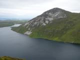 Aghla MoreMountain / peak · 3.5 mi
Explorer Tom Aghla More is part of a local group called the Seven Sisters. I have to ask if they ever get bored of each other, or if that is just what mountains do when they stand close enough to gossip.
 Astelleen Burn WaterfallWaterfall · 4.4 mi
Explorer Tom Astelleen Burn Waterfall, meaning torrent or flood, sloping down three kilometers southwest of Glenveagh Castle is a hidden gem.
More woods, forests and old trees in County Donegal · All of County Donegal

What do you know about this place?Tap to add a comment or ask a question