DDiscover AloneMapAbout

Lake View

House
Lake View
Photo: National Inventory of Architectural Heritage · Report the wrong picture

This does not grant access. Most recorded buildings are privately owned; view them only from public ground unless the owner allows entry.

What do you know about this place?Tap to add a comment or ask a question

What you write will be public.

What is recorded here

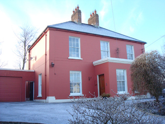
Detached three-bay two-storey house, built c. 1860, having central single-bay single-storey flat-roofed entrance porch to the front elevation (north-east), a two-storey with attic level block to the south-west. Possibly originally in use as a surgery or an official’s residence. Now in use as a private house with…

Read the whole record
Detached three-bay two-storey house, built c. 1860, having central single-bay single-storey flat-roofed entrance porch to the front elevation (north-east), a two-storey with attic level block to the south-west. Possibly originally in use as a surgery or an official’s residence. Now in use as a private house with single-bay single-storey flat-roofed garage extension to the south-east side elevation. Replacement hipped slate roof with projecting eaves course, two central red brick chimneystacks with clay pots over, and with cast-iron rainwater goods. Flat roof to entrance porch with decorative moulded cornice parapet. Pitched natural slate roof to block to the west having central brick chimneystack. Smooth rendered ruled-and-lined walls over projecting smooth rendered plinth course, and with smooth rendered pilasters to the corners of main body of building having moulded smooth rendered plinths\pedestals to base, and with moulded render cornices over. Smooth rendered pilasters to corners of porch. Square-headed window openings having painted stone sills, and with six-over-six-pane timber sliding sash windows. Some four-over-two pane timber sliding sash windows to the west side elevation; square-headed opening to the south elevation of block to the south-west at ground floor level having fixed multi-pane timber window. Square-headed doorway to the east side of entrance porch having replacement timber panelled door. Single-storey outbuilding to the south-east of house, built c. 1860 and linked to house by modern garage extension having hipped and pitched natural slate roof, roughcast rendered walls, and square-headed openings. Set back from road in own grounds to the south\south-east of the centre of Milford. Mature gardens to the front (north) and to the west; tarmacadam driveway and forecourt to the north. Partially rendered rubble stone boundary wall to road-frontage to the north; wall rebuilt to the east side of gateway. Main gateway to the north-east of site comprising a pair of ashlar gate piers (on square-plan) having plinths to base, moulded cut stone coping over, and with a pair of wrought-iron gates with cast-iron finials. Hooped wrought-iron railings to the garden to the west of site and rubble stone boundary wall to the rear (south).
This attractive and well-proportion middle-sized house, originally dating to the mid-nineteenth century, retains its early form and character. Its visual appeal and integrity are enhanced by the retention of salient fabric such as the timber sliding sash windows. Modest decorative interest is added by the pilasters to the corners of the front elevation with moulded detailing to base and head, and by the moulded cornice to the porch. The tall brick chimneystacks add a central focus (along with the porch) and help to add some interest to the roofscape. This building is typical of many contemporary houses built by wealthy professionals and merchants, and is one of the better examples of its type in the Milford area. This house was possibly the home of a William Reid in 1862, Clerk and Returning Officer for Milford Union (Thom’s Almanac). It was the residence of a William Reid in 1881 who was the Superintendent Registrar of Births, Deaths and Marriages at the time (Slater’s Directory). It was possibly the home of a W. H. C. Clarke in 1894 and was later the residence of a Dr (W.H.C.?) Clarke in 1910 (Ulster Towns Directory). This suggests that this house may have been originally also functioned as a surgery or office etc. and, perhaps, was originally built in an official capacity by the Poor Law Union (perhaps associated with the former Milford Poor Law Union workhouse that stood a short distance to the south-east, recently demolished), Grand Jury or some other body operating at the time. The two-storey block to the rear with the large multi-pane window at ground floor level may have been originally in use as an office or surgery associated with these former functions. This fine and well-maintained building is an integral element of the built heritage of the Milford area, and is an attractive feature along the main approach road into the town from the south-east. The outbuilding to the south-east, the hooped wrought-iron railings to the west side of the garden, the rubble stone boundary wall, and the fine gateway with well-crafted ashlar gate piers and metal gates in particular adds significantly to the setting and context, and completes this composition.

From the Buildings of Ireland (National Inventory of Architectural Heritage) record 40818013

Places near here

Photo credits
  • Kenneth Allen, Geograph · CC BY-SA 2.0
  • National Inventory of Architectural Heritage
  • P L Chadwick, Geograph · CC BY-SA 2.0
  • John M, Geograph · Creative Commons Attribution-ShareAlike 2.0
  • Maker not stated on source page, en.wikipedia.org
  • Proinsias Carr / Donegal GAA, donegalgaa.ie
  • Maker not stated on source page, www.dreamstime.com
  • Maker not stated on source page, www.pinterest.com
  • Maker not stated on source page, commons.wikimedia.org
St. Peter's Catholic ChurchChurch/chapel · 66 yd

Explorer Tom St. Peter's Catholic Church has a rooster on top that probably thinks it is in charge of the whole town. I bet every…

store/warehouse67 yd

Explorer Tom Store or warehouse in Fogher has a pulley mechanism hanging right above the second-floor windows! Built around 1860, I…
Donegal YMCA\Milford Community Youth ProjectHouse · 109 yd

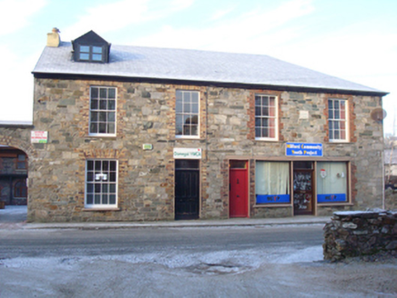
Explorer Tom Donegal YMCA in Fogher used to be two sweet houses but now one has a shopfront slapped on it like a bad sticker. A…

The Travellers InnHouse · 206 yd

Explorer Tom The Travellers Inn has a rounded corner made to spare it from passing traffic. Dated 1867, it may be Milford's earliest…

The Traveller's InnRestaurant · 206 yd

Explorer Tom The Traveller's Inn at Kilmacrennan Road junction might be hiding a map in the sauce. I bet the chef knows where the…
Milford Drapery and InteriorsStore/warehouse · 222 yd

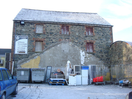
Explorer Tom Milford Drapery and Interiors was built by someone who really wanted to sell fabric but ended up selling bricks…

Milford Reformed Presbyterian ChurchChurch/chapel · 242 yd

Explorer Tom Milford Reformed Presbyterian Church has a curse that only hits people who don't wave at it first, so make sure you're…

Mapped cemeteryCemetery · 344 yd

Explorer Tom Mapped cemetery handles nosy neighbours by pretending not to hear them, which is an ancient skill that takes decades of…

Moyle View Park, Milford GAAGAA ground · 564 ydMapped graveyardGraveyard · 837 yd

Explorer Tom This unnamed graveyard in County Donegal had a massive falling out with the next village over who stole their windmill…

Megalithic tomb in MillfordMegalithic tomb · 977 yd

Explorer Tom Megalithic tomb in Millford is basically a giant's grave that forgot to show up. Lewis swore he saw it back in eighteen…

Standing stone in MillfordStanding stone · 994 yd

Explorer Tom Standing stone in Millford is a proper chunky guy, measuring .75m high × 1.5m wide at base. It looks like it’s been…

More historic places in County Donegal · All of County Donegal

Add to this placeAdd a picture Add a detailed tip Add a story

Explore the map1,095,414 places to discover

Next place · or swipeSt. Peter's Catholic Church